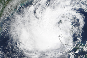

At 11:05 a.m. local time (03:05 UTC) on October 19, 2015, the Moderate Resolution Imaging Spectroradiometer (MODIS) on NASA’s Terra satellite acquired this image of Typhoon Koppu over the Philippines.
When this image was acquired, the typhoon was a Category 1-strength storm with maximum sustained winds of about 130 kilometers (80 miles) per hour. The storm had already weakened from super typhoon status with 240 kilometer (150 mile) per hour winds, recorded on October 17, according to Unisys. Weakening continued and by the evening of October 19—about nine hours after this image—Koppu was downgraded to a tropical storm.
Although Koppu had weakened, the threat of flooding lingered. According to Weather Underground blogger Bob Henson, models agreed that the storm would spend another three to four days creeping northward along Luzon—the largest, northernmost island in the Philippines. Moisture over the island could produce total rainfall amounts of at least 0.3 to 0.6 meters (12 to 24 inches) of across much of northern Luzon. Some models pointed toward localized regions of that could see far higher rainfall totals, upward of 1 to 1.3 meters (40 to 50 inches).
NASA image by Jeff Schmaltz, LANCE/EOSDIS Rapid Response. Caption by Kathryn Hansen.
Typhoon Koppu has weakened, but the system is still expected to bring widespread flooding to the Philippine’s Luzon Island.
Typhoon Koppu brought devastating rain and flooding to The Philippines in October 2015.

