
Typhoon Phanfone barreled into southern Japan at about 8 a.m. local time on October 6, 2014 (11 p.m. Universal Time on October 5). The category 1 storm made landfall in Shizuoka Prefecture with maximum sustained winds of about 130 kilometers (80 miles) per hour.
Phanfone dumped 48 centimeters (19 inches) of rain in the mountainous region of Shizuoka Prefecture. At one point during the storm, rain fell in Shizuoka—the capital city of the prefecture—at a record-rate of 8.7 centimeters (3.4 inches) per hour. The 667,000 people living in the prefecture were urged to evacuate to safer ground.
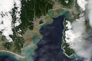
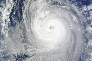
The intense rain and resulting runoff led to sediment plumes in Suruga Bay, visible in the natural-color image (top) acquired October 6, 2014, by the Moderate Resolution Imaging Spectroradiometer (MODIS) on NASA's Aqua satellite. Such plumes were not apparent on September 29 (bottom image).
Phanfone later turned northeast and headed for Tokyo, bringing torrential rain and strong winds to the city before moving out to sea.
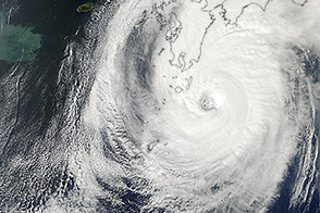
On October 5, the day before Phanfone made landfall, the MODIS instrument on NASA's Aqua satellite acquired this view of the storm.
NASA Earth Observatory images by Jesse Allen, using data from the Land Atmosphere Near real-time Capability for EOS (LANCE). Caption by Kathryn Hansen.
Image of the Day Atmosphere Land Water Severe Storms
Rain and resulting runoff from Typhoon Phanfone created sizeable sediment plumes off the coast of Japan.
Image of the Day for October 7, 2014
Typhoon Phanfone struck Japan in October 2013.


