

Smoke from the Rim Fire choked Yosemite National Park during the busy Labor Day weekend. Air quality reached unhealthy levels from Yosemite to the San Joaquin Valley, according to an air quality alert from the National Weather Service. People were advised to avoid strenuous outdoor activity or to remain indoors because fine particles in smoke can irritate the eyes and respiratory system and aggravate chronic heart and lung disease.
The Moderate Resolution Imaging Spectroradiometer (MODIS) on NASA’s Aqua satellite acquired this view of the fire on August 31, 2013. Red boxes outline the active fire areas. The smoke is brown and smooth in texture compared to the bright white clouds; it was thick enough at the time to entirely block the view of the ground from space.
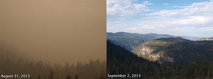
For people in the park, the smoke obscured Yosemite’s normally pristine views. The lower photos from the National Park Service’s Turtleback Dome webcam contrast August 31 and September 2, 2013. Turtleback Dome is south of the Rim Fire, immediately west of Yosemite Valley. Though smoke had the greatest impact on local communities, Aqua’s AIRS instrument tracked carbon monoxide from the plume across much of North America.
By September 2, the Rim Fire had burned 228,670 acres (357 square miles), making it the largest fire in the United States so far in 2013. The fire was 60 percent contained and threatening 4,500 buildings. Eleven homes and 100 other buildings have been destroyed. The fire started on August 17 and is expected to be contained by September 20.
NASA image courtesy Jeff Schmaltz, LANCE/EOSDIS MODIS Rapid Response Team at NASA GSFC. Photos courtesy National Park Service. Caption by Holli Riebeek.