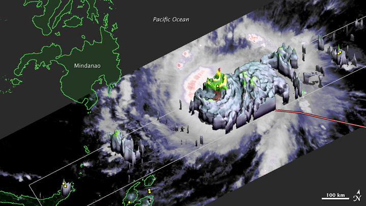


The Tropical Rainfall Measurement Mission (TRMM) satellite observed the eye wall of super typhoon Bopha in three dimensions on Monday, December 3, 2012 ( just before noon local time). At that time, Bopha was a category 3 storm and had begun rapidly intensifying to category 5 prior to landfall the next morning on the Philippine island of Mindanao.
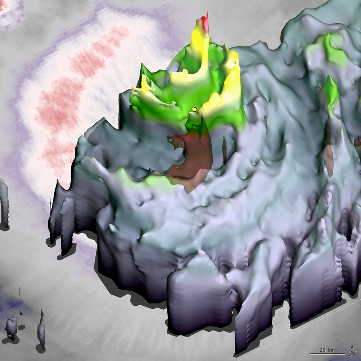
The TRMM satellite saw potentially destructive indicators in the eyewall of the tropical cyclone. The TRMM radar saw two hot towers simultaneously reaching a 15.5 kilometers in altitude on the northeast side of the eyewall, where the storm’s forward motion is added to the counter-clockwise winds circling under the eyewall. TRMM studies have suggested that even a single hot tower exceeding a 14.5 km height may be sufficient to indicate intensification is ongoing. At the base of the hot towers, radar reflectivity indicated heavy rainfall (as shown in deep red in the image).
The TRMM radar also saw a double eyewall—two concentric rings of intense storm cells exceeding a 12 kilometers in altitude. Yellows and greens indicate the locations inside the typhoon where updrafts were lifting precipitation-size ice between 9 and 12 kilometers above the ocean. Concentric eyewalls are generally evidence of an eyewall replacement cycle, which can be associated with rapid intensification.
While most tropical-cyclone-observing instruments are passive microwave instruments which give altitude-integrated images with somewhat “fuzzy” horizontal resolution, the TRMM radar is like a high-definition camera with a flash that reveals vertical structure. The TRMM radar revealed that the inner eyewall had only a 20 kilometer radius, which is smaller than the average tropical cyclone.
The small radius of the inner eyewall is the third indicator of Bopha’s fearsome potential. A compact eyewall means that the typhoon’s eye contains only a relatively small volume of air that would need to be heated in order to lower the storm’s ocean-surface central pressure. That, in turn, would make is easier to increase the speed of the circling surface winds that determine the storm’s intensity.
Fourth, the TRMM radar saw two lightning flashes in the inner edge of one of the hot towers. Lightning flashes are relatively rare in eyewalls, tending to occur where updrafts are strong enough to suspend a mix of supercooled water and hail-sized chunks of ice. Such large chunks of ice can only form when updrafts repeatedly “bob” ice particles up and down through a lower cloud layer with liquid water droplets and then a higher cloud layer cold enough to promote freezing.
TRMM also observed cloud-top temperatures, which provide a fifth indicator that the inner-core energy-conversion machinery of Supertyphoon Bopha was working in overdrive. Specifically, the coldest cloud tops were observed with extremely cold temperatures below -90°C, indicating that Bopha was extracting a great deal of energy from the ocean surface and converting it into strong updrafts that where punching into the transition zone between the troposphere and stratosphere.
As a bonus, the cloud-top temperatures clearly illustrate how the circling winds can act as a “containment vessel” preventing at least some of the energy released in hot towers from dissipating harmlessly far from the cyclone’s inner core. Specifically, the cloud-top temperatures show gravity waves propagating around the eyewall instead of spreading away from the inner core.
A joint mission between the United States and Japan, the TRMM satellite just passed the 15th anniversary of its launch. An advantage of an extended mission is that it increases the chances of observing rare and poorly understood events, such Bopha, a category 5 tropical cyclone close to the Equator.
NASA images and caption by Owen Kelley, NASA Goddard Space Flight Center.