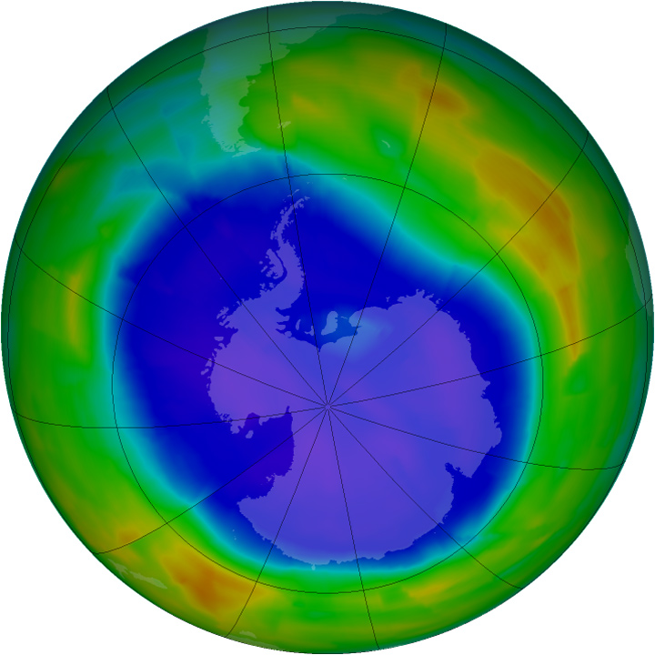


Scientists from NASA and the National Oceanic and Atmospheric Administration confirmed today that ozone depletion over the South Pole in 2011 has reached its annual maximum. Researchers used satellites, ground based monitors, and instrumented balloons to observe the hole, finding it to be among the top 10 worst for the breadth and depth of ozone loss in the 26 year record.
The south pole-centered map above is based on data from the Ozone Monitoring Instrument (OMI) on the Aura satellite. OMI is a spectrometer, built for the NASA satellite by scientists in The Netherlands and Finland, that measures the amount of sunlight scattered by Earth’s atmosphere and surface. OMI allows scientists to assess how much ozone is present at various altitudes—particularly the stratosphere—and near the ground.
The image shows the extent, or geographic area, of the ozone hole at its widest on September 12, 2011, when it stretched 10.05 million square miles (26.03 million square kilometers). The lowest concentration of ozone in the southern stratosphere—that is, the deepest “hole”—occurred on October 9, 2011, when levels descended to 95 Dobson units. The hole isn’t literal; no part of the stratosphere is empty of ozone. But scientists use the hole metaphor to describe the area where ozone drops below a historical concentration of 220 Dobson Units.
“The colder than average temperatures in the stratosphere this year caused a larger than average ozone hole,” said Paul Newman, chief scientist for atmospheres at NASA's Goddard Space Flight Center. “Even though it was relatively large, the area of this year's ozone hole was within the range we’d expect, given the levels of manmade ozone-depleting chemicals that continue to persist in the atmosphere.”
Earth's ozone layer protects life by absorbing ultraviolet light, which damages DNA in plants and animals (including humans) and leads to skin cancer. The problem is serious enough that government agencies in New Zealand and Australia regularly warn their citizens to protect themselves from the Sun when the ozone hole develops each year.
The measurements from OMI continue a legacy of monitoring the ozone layer from space that dates back to 1972 with launch of the Nimbus-4 satellite. You can view the historical progress of the ozone hole by visiting NASA’s Ozone Hole Watch page.
NASA image courtesy Ozone Hole Watch. Caption by Michael Carlowicz and Patrick Lynch.