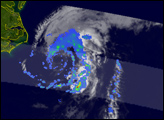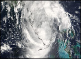
Rains from Tropical Storm Beryl were already affecting Long Island when the Moderate Resolution Imaging Spectroradiometer (MODIS) on NASA’s Aqua satellite captured this image at 2:00 p.m. Eastern Daylight Time (18:00 UTC) on July 20, 2006. The storm formed a loose spiral of clouds as it moved up the U.S. East Coast at 17 kilometers per hour (11 miles per hour). At the time, the storm’s winds were 95 km/hr (60 mph), with stronger gusts, reported the National Hurricane Center. Later in the day and into July 21, Beryl’s center passed over Nantucket Island and clipped Cape Cod. The National Hurricane Center expected the storm to pass over Nova Scotia, Canada, on Friday, July 21, and strike Newfoundland the next day.
Beryl was offshore of New Jersey, Long Island, and Connecticut when MODIS captured this photo-like image. The silver streak over the ocean to the left of the storm is the Sun’s reflection off the water. Tropical Storm Beryl formed in the northwestern Atlantic on July 18, 2006, roughly 200 kilometers (120 miles) southeast of North Carolina’s Outer Banks. Later that day, the storm gathered just enough power to reach tropical storm status and become the second named storm system of the 2006 Atlantic hurricane season.
The high-resolution image provided above is provided at the full MODIS spatial resolution (level of detail) of 250 meters per pixel. The MODIS Rapid Response System provides this image at additional resolutions.
NASA image by Jeff Schmaltz, MODIS Rapid Response Team, Goddard Space Flight Center.
alert message