
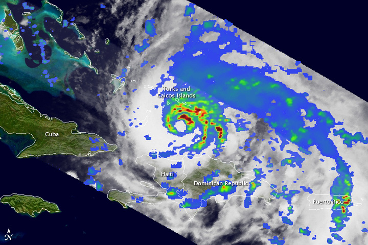
The Tropical Rainfall Measuring Mission (TRMM) satellite passed directly over Hurricane Irene late on August 23, 2011, capturing these images of a storm getting ready to intensify. Irene was bearing down on parts of the Caicos Islands when the images were taken at 23:11 Universal Time (7:11 p.m. Eastern Daylight Time).
The first image shows a top-down view of rain intensities within Irene. Though Irene does not appear to have an eye in visible satellite imagery, TRMM reveals an eye and complete eye wall of varying rain intensities deep down under the cloud tops. The northeast corner of the eye contains an area of intense rain (darker red area), while the southern portion contains only light rain (shown in blue). Moderate rain (green areas) makes up the rest of the eye wall. However, the storm is still fairly asymmetrical, however, with most of the surrounding rain northeast of the center.
Rain rates in the center of the swath are from the higher resolution TRMM Precipitation Radar, while those in the outer swath are from the TRMM Microwave Imager. The rain rates are overlaid on visible and infrared data from the TRMM Visible Infrared Scanner.
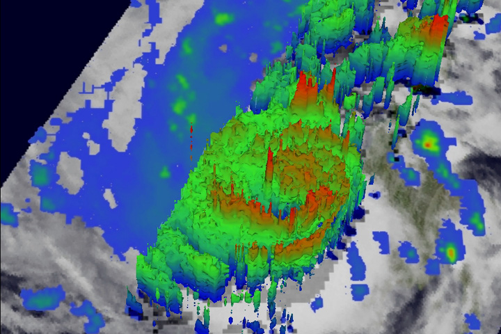
The lower image, taken at the same time, shows a three dimensional view of Irene. Areas in red mark the tops of deep convection towers, where precipitation-sized particles are being carried higher into the atmosphere by strong thunderstorms. These storms-within-a-storm can intensify hurricanes by releasing large amounts of latent heat via condensation. This heat can intensify the circulation, especially when released near the storm's core.
TRMM shows several towers both near the center and in the outer rain bands with tops near 15 kilometers (brighter red areas). These areas are associated with the areas of intense rain seen in the previous image. Also, evident at this time is an area of shallow tops (in blue) near to the center where drier air had worked its way into the storm.
At the time of these images, Irene was a Category 1 storm with sustained winds of 80 knots (about 90 mph). However, the central pressures were already beginning to fall and Irene re-intensified into a Category 2 storm just over 6 hours later.
Images produced by Hal Pierce. Caption by Steve Lang and Hal Pierce.
Irene formed as a tropical storm east of the Leeward Islands on August 20, 2011. By August 24, the storm had strengthened to a Category 3 hurricane.
