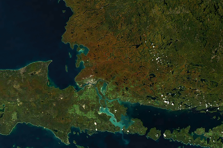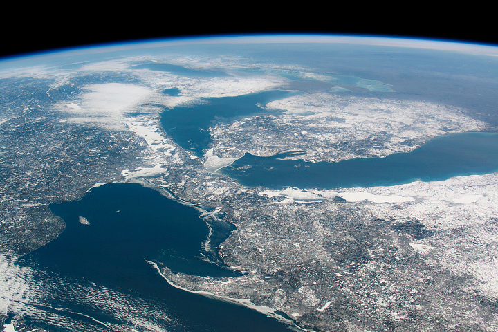
The twin cities of Sault Ste Marie are located across the St. Mary’s River, which forms part of the international boundary between Canada (province of Ontario) and the United States (state of Michigan). This astronaut photograph highlights the two cities, as well as the lakes and islands that separate Lakes Huron and Superior, two of the Great Lakes of North America. Smaller lakes (including Lake George) and the large forested islands of St. Joseph and Drummond are visible east of the city (upper right in the image).
The image is oriented with north on the left. The Sault Ste Marie urban areas (image lower left) have a distinctive gray to white color, contrasting with the deep green of forested areas in Ontario and the lighter green of agricultural fields in Michigan. The water surfaces in the lakes and rivers vary from blue to blue-green to silver, likely the result of varying degrees of sediment and sunglint—light reflecting from the water surface back to the International Space Station.
Prior to formalization of the US-Canada border in 1817, Sault Ste Marie was a single community. Archeological evidence suggests the region was occupied by Native Americans at least five hundred years ago. A mission—the first European settlement in Michigan—was established there in 1668 by the French Jesuit Father Jacques Marquette. Today, shipping locks and canals in both urban areas are an important part of the Great Lakes shipping traffic system.
Astronaut photograph ISS028-E-10162 was acquired on June 29, 2011, with a Nikon D2Xs digital camera using a 110 mm lens, and is provided by the ISS Crew Earth Observations experiment and Image Science & Analysis Laboratory, Johnson Space Center. The image was taken by the Expedition 28 crew. The image has been cropped and enhanced to improve contrast. Lens artifacts have been removed. The International Space Station Program supports the laboratory as part of the ISS National Lab to help astronauts take pictures of Earth that will be of the greatest value to scientists and the public, and to make those images freely available on the Internet. Additional images taken by astronauts and cosmonauts can be viewed at the NASA/JSC Gateway to Astronaut Photography of Earth. Caption by William L. Stefanov, Jacobs/ESCG at NASA-JSC.