

Hurricane Earl had strengthened further by August 31, 2010. At 2:00 a.m. Atlantic Standard Time (AST) that day, the U.S. National Hurricane center reported that Earl was located roughly 125 miles (200 kilometers) north of San Juan, Puerto Rico, and was moving toward the west-northwest. The storm had maximum sustained winds of 135 miles (215 kilometers) per hour.
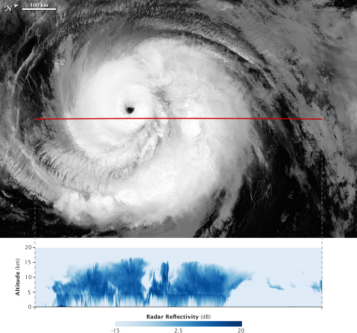
This image pair shows a grayscale view of Hurricane Earl captured by the Moderate Resolution Imaging Spectroradiometer (MODIS) on NASA’s Aqua satellite (top) combined with a profile of the vertical structure of the clouds measured by the radar on the Cloudsat satellite (bottom). The images were acquired around 2:20 a.m. AST (06:20 UTC) on August 31, 2010.
The Aqua image has been rotated so that north is to the right. The red line shows the track that Cloudsat followed as it passed over the storm a few minutes after Aqua. The radar reflectivity measured by Cloudsat is the echo from the pulse of energy the radar sends out bouncing back from the ocean surface or from cloud particles in the atmosphere. If you could cut a north-south line through the hurricane, clear away half, and look at the storm from the side, the cloud heights would roughly mimic this profile.
NASA Earth Observatory image created by Jesse Allen, using CloudSat FirstLook data provided courtesy of the CloudSat team at Colorado State University. Caption by Michon Scott.