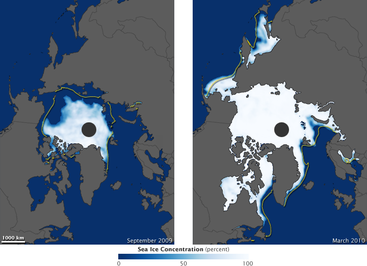


Satellites have continually monitored polar sea ice since 1979, and since the turn of the twenty-first century, Arctic sea ice has declined relative to its 1979–2000 mean extent. According to the National Snow and Ice Data Center (NSIDC), sea ice extent at the most recent summer minimum (September 2009) and winter maximum (March 2010) was greater than it had been in the most recent years, but this short-term gain did not yet indicate a reversal of the long-term decline.
This pair of images shows the latest updates to the the Earth Observatory’s World of Change: Arctic Sea Ice feature. They show Arctic sea ice extent for the September 2009 minimum (left) and March 2010 maximum (right). In both images, gray indicates land, dark blue indicates ice-free ocean water, and white indicates ice concentrations. Yellow lines in each image indicate the median for that month based on observations from 1979 to 2000. The images are based on data from the Advanced Microwave Scanning Radiometer for EOS (AMSR-E), a Japanese-built sensor that flies on NASA’s Aqua satellite.
In September 2009, average Arctic sea ice extent was 5.36 million square kilometers (2.07 million square miles). Although this was 1.06 million square kilometers (409,000 square miles) above the record low in September 2007, it was still 1.68 million square kilometers (649,000 square miles) below the 1979–2000 average for September.
In March 2010, average Arctic sea ice extent was 15.10 million square kilometers (5.83 million square miles). This was 670,000 square kilometers (260,000 square miles) above the record low, set in March 2006, but it was also 650,000 square kilometers (250,000 square miles) below the 1979–2000 average for March.
The winter sea ice extent originally appeared to have peaked in early March and started its spring thaw, but, encouraged by cold winds over the Bering and Barents Seas, sea ice resumed growing later in the month. As a result, sea ice extent for the Arctic actually peaked on March 31, 2010—the latest peak of wintertime Arctic sea ice extent in the satellite record. Despite the surge of ice formation in late March, the late-season ice was thin and vulnerable to summertime melt.
Although unusual for the past decade, the late-season growth spurt probably doesn’t indicate a return to normal sea ice conditions. NSIDC’s lead scientist Ted Scambos remarked, “This is a variable system and we are experiencing a long-term decline, not a minute-by-minute decline.” In other words, even as Arctic climate continues to warm over the long-term, there won’t be a new record low ice extent each year.
NASA image created by Jesse Allen, using AMSR-E data courtesy of the National Snow and Ice Data Center (NSIDC), and sea ice extent contours courtesy of Terry Haran and Matt Savoie, NSIDC, based on Special Sensor Microwave Imager (SSM/I) data. Caption by Michon Scott.