
Mayon Volcano, on the Philippine island of Luzon, continued its activity on December 28, 2009. Described as showing an “intense level of unrest” by the Philippine Institute of Volcanology and Seismology, Mayon exhibited 7 ash explosions, dozens of earthquakes related to the movement of magma beneath the volcano, over 100 rock falls from the summit, and 3 active lava flows. The Philippine government is enforcing evacuations in a danger zone extending 7 kilometers (4 miles) north and 8 kilometers (5 miles) south of the summit.
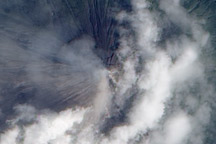
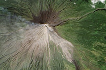
This satellite image shows Mayon emitting a thin volcanic plume. Ash obscures the summit crater and clouds hide lava flows on the volcano’s flanks. The natural-color image was acquired by the Advanced Land Imager (ALI) aboard the NASA Earth Observing-1 (EO-1) satellite.
NASA Earth Observatory image by Robert Simmon, using EO-1 ALI data provided by the NASA EO-1 team. Caption by Robert Simmon.
In late December 2009, the volcano hazard at Mayon Volcano in the Philippines reached Alert Level 4, which means “a hazardous explosive eruption is possible within days.â€

