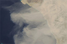
In the summer months in the Northern Hemisphere, dust storms originating in the deserts around the Arabian Peninsula have a significant impact on the amount of solar radiation that reaches the surface. Winds sweep desert sands into the air and transport them eastward toward India and Asia with the seasonal monsoon. These airborne particles absorb and deflect incoming radiation and can produce a cooling effect as far away as North America.
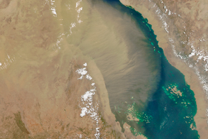
According to calculations performed by the NASA Goddard Institute for Space Studies (GISS), the terrain surrounding the southern portions of the Red Sea is one of the areas most dramatically cooled by the presence of summertime dust storms. That region is shown experiencing a dust storm in this true-color image from the Moderate Resolution Imaging Spectroradiometer (MODIS) acquired on July 11, 2002. The GISS model simulations indicate that between June and August, the temperatures would be as much as 2 degrees Celsius warmer than they are if it weren't for the dust in the air—a cooling equivalent to the passage of a rain cloud overhead.
The image shows the African countries of Sudan (top left), Ethiopia (bottom left), with Eritrea nestled between them along the western coast of the Red Sea. Toward the right side of the image are Saudi Arabia (top) and Yemen (bottom) on the Arabian Peninsula. Overlooking the Red Sea, a long escarpment runs along the western edge of the Arabian Peninsula, and in this image appears to be blocking the full eastward expansion of the dust storm.
Image courtesy Jacques Descloitres, MODIS Land Rapid Response Team at NASA GSFC
alert message