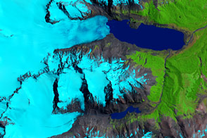
Outside of Antarctica, the largest contiguous ice field in the Southern Hemisphere is the Southern Patagonian Ice Field in the Andes Mountains of Chile and Argentina. It has an area of about 13,000 square kilometers, a length of approximately 360 kilometers (over three degrees of latitude), and an average width of about 40 kilometers.
To the west of the ice field, nearly fifty significant outlet glaciers reach sea level in rugged fiords on the Pacific coast. The largest of these, Brüggen, was featured in a previous image on Earth Observatory. East of the ice field, several of the larger glaciers on the eastern flank form large piedmont lakes (such as Lago Argentina).
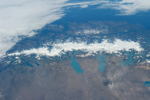
Whether taken on the ground or by remote sensing satellites, scientific measurements of the ice field and its glaciers are difficult to obtain due to the rugged terrain and harsh, stormy climate of the region. The estimated loss of ice mass of this large system is an important indicator of climate variability on both a local and global scale. Additional information on this and other Patagonian glaciers may be found at the following link: USGS ? Historic Fluctuations of Outlet Glaciers from the Patagonian Ice Fields.
This image is a mosaic of two digital photographs (ISS004-ESC-6737 and ISS004-ESC-6738) taken by astronauts onboard the International Space Station in January 2002. Images were provided by the Earth Sciences and Image Analysis Laboratory at Johnson Space Center. Additional images taken by astronauts and cosmonauts can be viewed at the NASA-JSC Gateway to Astronaut Photography of Earth.