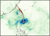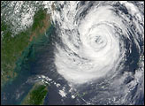
Typhoon Kalmaegi was grazing the Pacific-facing coast of Taiwan in the morning hours of July 17, 2008. The Category 2 typhoon raised alarms on land and sea. The Central Weather Bureau in Taipei, Taiwan’s capital, forecasted that the storm would bring high winds and heavy rain to the island throughout the day. The storm was predicted to touch land briefly at the island’s northern tip before crossing the straits between Taiwan and China.
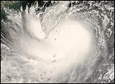
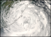
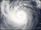
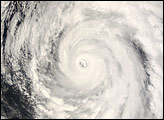
This natural-color satellite image of Typhoon Kalmaegi was obtained by the Moderate Resolution Imaging Spectroradiometer (MODIS) on NASA’s Terra satellite at 10:25 a.m. local time (2:25 UTC) on July 17, 2008. The storm system had the distinctive swirling shape of a typhoon, but lacked the well-developed spiral arms and distinct central eye that characterize mature, powerful systems.
As of July 17, Typhoon Kalmaegi was predicted to make a second landfall on China’s coast, possibly building to Category 3 status beforehand.
The high-resolution image provided above is at MODIS’ full spatial resolution (level of detail) of 250 meters per pixel. The MODIS Rapid Response System provides this image at additional resolutions.
NASA image by Jeff Schmaltz, MODIS Rapid Response Team, Goddard Space Flight Center. Caption by Jesse Allen.