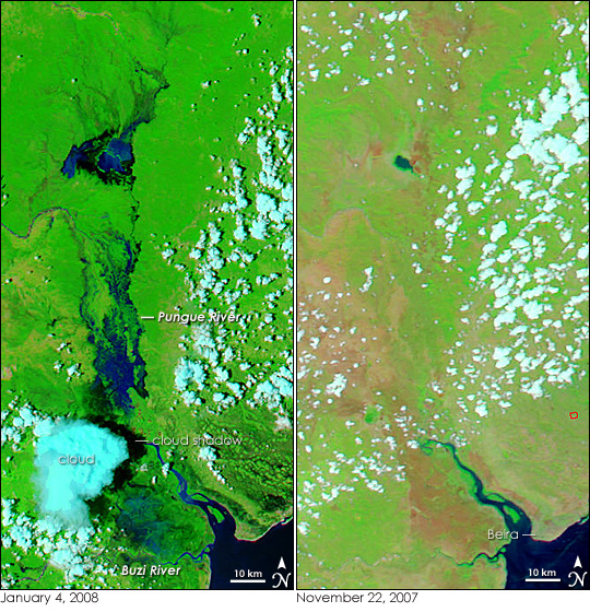
Summer floods are a way of life along the rivers that run across southern Africa. The rainy season begins in October, builds to a climax during December through March, and then tapers off in April, delivering much of the region’s annual rainfall. By February or March during the typical rainy season, the intense rain puddles on the saturated ground and pushes brimming rivers, reservoirs, and lakes over their banks. In 2008, the floods began in January.
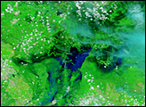
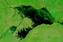
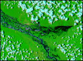
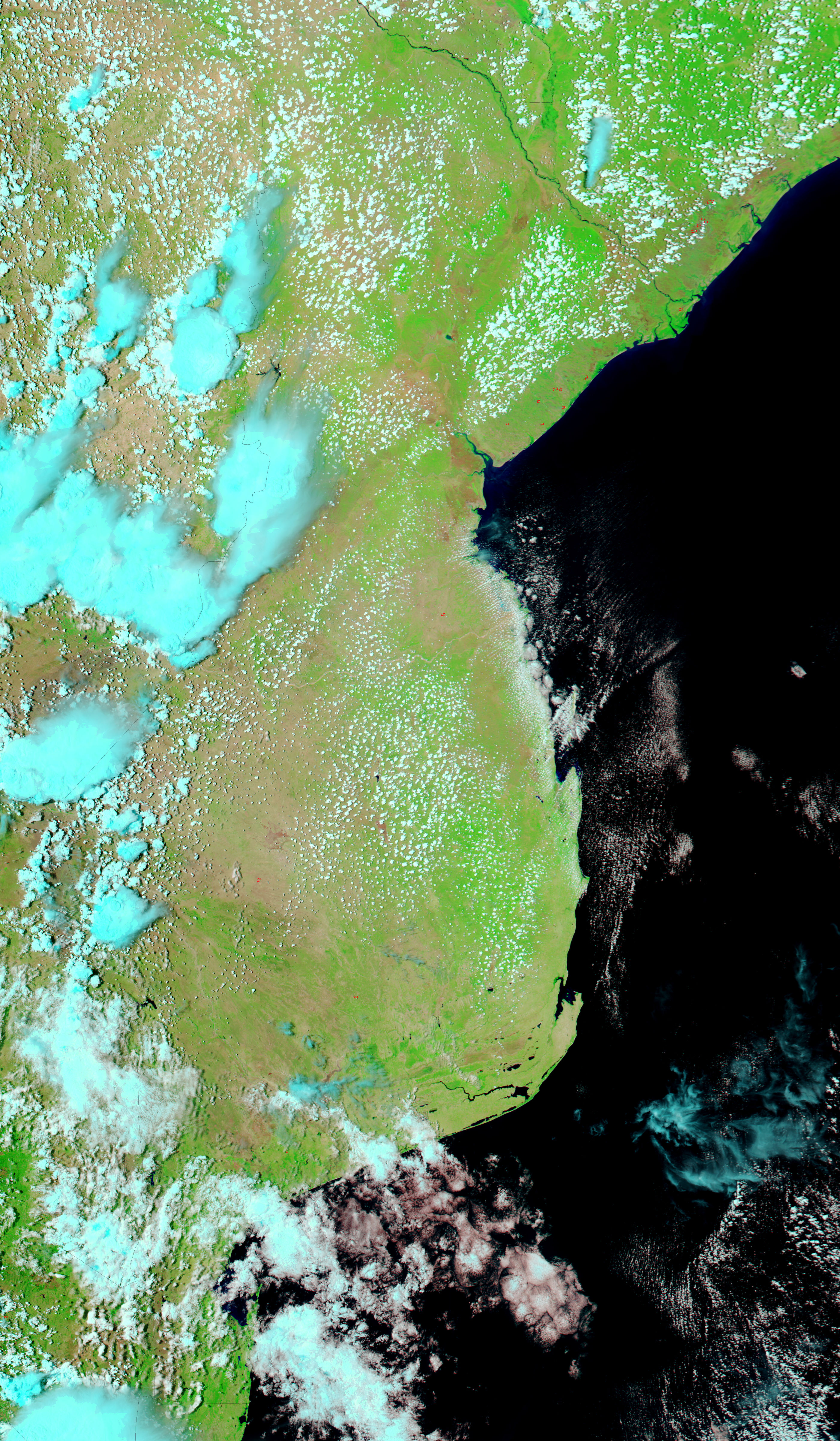
The Moderate Resolution Imaging Spectroradiometer (MODIS) flying on NASA’s Aqua satellite captured the left image of flooding in Mozambique on January 4, 2008. The heavy rains that normally come later in the rainy season began in December 2007, leading to early floods. The extent of the floods around the city of Beira can be seen by comparing the flood scene with the image on the right, which was taken by the same sensor on November 22, 2007, before the intense rains started. Both images were made with a combination of infrared and visible light to increase the contrast between earth and mud-laden flood water. In this type of image, water is black, or dark blue when filled with sediment. Bare or sparsely vegetated land is tan, and plant-covered land is bright green. Clouds are light blue and white. A red square outlines the location of a fire on November 22.
As early as January 4, the south-flowing Pungue River and the east-flowing Buzi River flowed over their banks. The black, web-like tangle and blue kilometers-wide lake around the Pungue River reveal that seasonal wetlands are filling with water. Resembling the muted strokes in a watercolor, brushes of blue blend into green north of the Buzi River where the ground is saturated and muddy. Darker black pools north and east of Beira are likely standing water.
The early floods forced the evacuation of 13,000 people throughout Mozambique, reported the United Nations Office for the Coordination of Humanitarian Affairs on January 7. Neighboring Zimbabwe and Zambia were also flooded as heavy rain inundated the Zambezi River basin. The United Nations reported concern that the early floods could be a precursor to more substantial flooding later in the rainy season.
To monitor the flood situation throughout the rainy season, see the twice-daily images of Mozambique produced by the MODIS Rapid Response System.
Summer floods are a way of life along the rivers that run across southern Africa. The rainy season begins in October, builds to a climax during December through March, and then tapers off in April, delivering much of the region’s annual rainfall. By February or March during the typical rainy season, the intense rain puddles on the saturated ground and pushes brimming rivers, reservoirs, and lakes over their banks. In 2008, the floods began in January.
The Moderate Resolution Imaging Spectroradiometer (MODIS) flying on NASA’s Aqua satellite captured the left image of flooding in Mozambique on January 4, 2008. The heavy rains that normally come later in the rainy season began in December 2007, leading to early floods. The extent of the floods around the city of Beira can be seen by comparing the flood scene with the image on the right, which was taken by the same sensor on November 22, 2007, before the intense rains started. Both images were made with a combination of infrared and visible light to increase the contrast between earth and mud-laden flood water. In this type of image, water is black, or dark blue when filled with sediment. Bare or sparsely vegetated land is tan, and plant-covered land is bright green. Clouds are light blue and white. A red square outlines the location of a fire on November 22.
As early as January 4, the south-flowing Pungue River and the east-flowing Buzi River flowed over their banks. The black, web-like tangle and blue kilometers-wide lake around the Pungue River reveal that seasonal wetlands are filling with water. Resembling the muted strokes in a watercolor, brushes of blue blend into green north of the Buzi River where the ground is saturated and muddy. Darker black pools north and east of Beira are likely standing water.
The early floods forced the evacuation of 13,000 people throughout Mozambique, reported the United Nations Office for the Coordination of Humanitarian Affairs on January 7. Neighboring Zimbabwe and Zambia were also flooded as heavy rain inundated the Zambezi River basin. The United Nations reported concern that the early floods could be a precursor to more substantial flooding later in the rainy season.
To monitor the flood situation throughout the rainy season, see the twice-daily images of Mozambique produced by the MODIS Rapid Response System.

NASA images courtesy the MODIS Rapid Response Team at NASA GSFC. Caption by Holli Riebeek.
By February or March during the typical southern African rainy season, the intense rain puddles on the saturated ground and pushes brimming rivers, reservoirs, and lakes over their banks. In 2008, the floods began in January and continued into February.


