The Earth Observatory has published its last Image of the Day on this website. Please join us on our new home at science.nasa.gov/earth/earth-observatory.

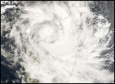
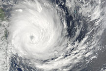
The Seychelles are a chain of islands stretching out north of Madagascar off the eastern coast of Africa. On December 20, 2006, these islands were on alert for the very intense tropical cyclone Bondo, which was predicted to strike the islands in the early hours of the next day. Cyclone Bondo was a Category 4 storm on the Saffir-Simpson scale, with sustained winds as high as 222 kilometers per hour (138 miles per hour), according to the Reuters news service.
This photo-like image was acquired by the Moderate Resolution Imaging Spectroradiometer (MODIS) on the Terra satellite on December 20, 2006, at 9:35 a.m. local time (6:35 UTC), while the storm’s center was drawing in towards the Seychelles. The island of Madagascar appears to the southwest of the storm (lower-left corner), where the outer rain bands from the storm were coming ashore. Bondo had well-defined, spiral arms of rainclouds and thunderstorms at the time of this image, and a strong and distinct, cloud-filled (or “closed”) eye at its center.
The high-resolution image provided above is at MODIS’ full spatial resolution (level of detail) of 250 meters per pixel. The MODIS Rapid Response System provides this image at additional resolutions.
You can also download a 250-meter-resolution Cyclone Bondo KMZ file for use with Google Earth.
NASA image by Jeff Schmaltz, MODIS Rapid Response Team, Goddard Space Flight Center.