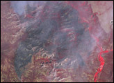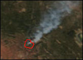

On the outskirts of Sedona, Arizona, the Brins Fire was burning rapidly in Coconino National Forest and threatening subdivisions and other residences in the area on June 19, 2006. The Moderate Resolution Imaging Spectroradiometer (MODIS) on NASA’s Terra satellite took this picture at 11:40 a.m. local time on Monday, June 19. The area in which MODIS detected actively burning fire is outlined in red. A smoke plume stretches northeast between Lake Mormon and Flagstaff. According to reports from the National Interagency Fire Center on June 20, the Brins Fire was more than 1,000 acres and was 5 percent contained.
The digital image above is provided at MODIS’ maximum spatial resolution (level of detail) of 250 meters per pixel. The large image shows a wider area at the same resolution. The MODIS Rapid Response System provides this image at additional resolutions.
NASA image courtesy the MODIS Rapid Response Team, Goddard Space Flight Center
In mid-June 2006, the Brins Fire was burning rapidly in Coconino National Forest and threatening homes near Sedona, Arizona.

