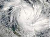
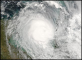
Tropical Cyclone Monica formed off the northeastern coast of Australia on April 17, 2006. This is the same general area where Cyclone Larry formed a month earlier. Larry caused devastation to Queenland’s coastal communities and destroyed a large fraction of the banana trees in the region. Cyclone Monica was not predicted to be anywhere near as destructive as Larry, and according to the Australian Bureau of Meteorology, Monica was expected to cross Cape York in northern Queensland well away from most settled areas, limiting the damage it was predicted to cause.
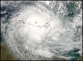
This photo-like image was acquired by the Moderate Resolution Imaging Spectroradiometer (MODIS) on the Terra satellite on April 18, 2006, at 10:35 a.m. local time (00:35 UTC). Cyclone Monica at this time had a basic spiral form, but lacked the well-developed eye and tight-wound shape of a powerful storm. Sustained, peak winds in the storm system were roughly 100 kilometers per hour (65 miles per hour) around the time the image was captured.
NASA image by Jesse Allen, Earth Observatory, using data obtained from the Goddard Earth Sciences DAAC.
Tropical Cyclone Monica formed off the northeastern coast of Australia on April 17, 2006. This is the same general area where Cyclone Larry formed a month earlier.
alert message