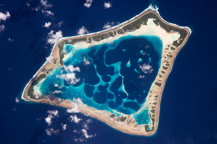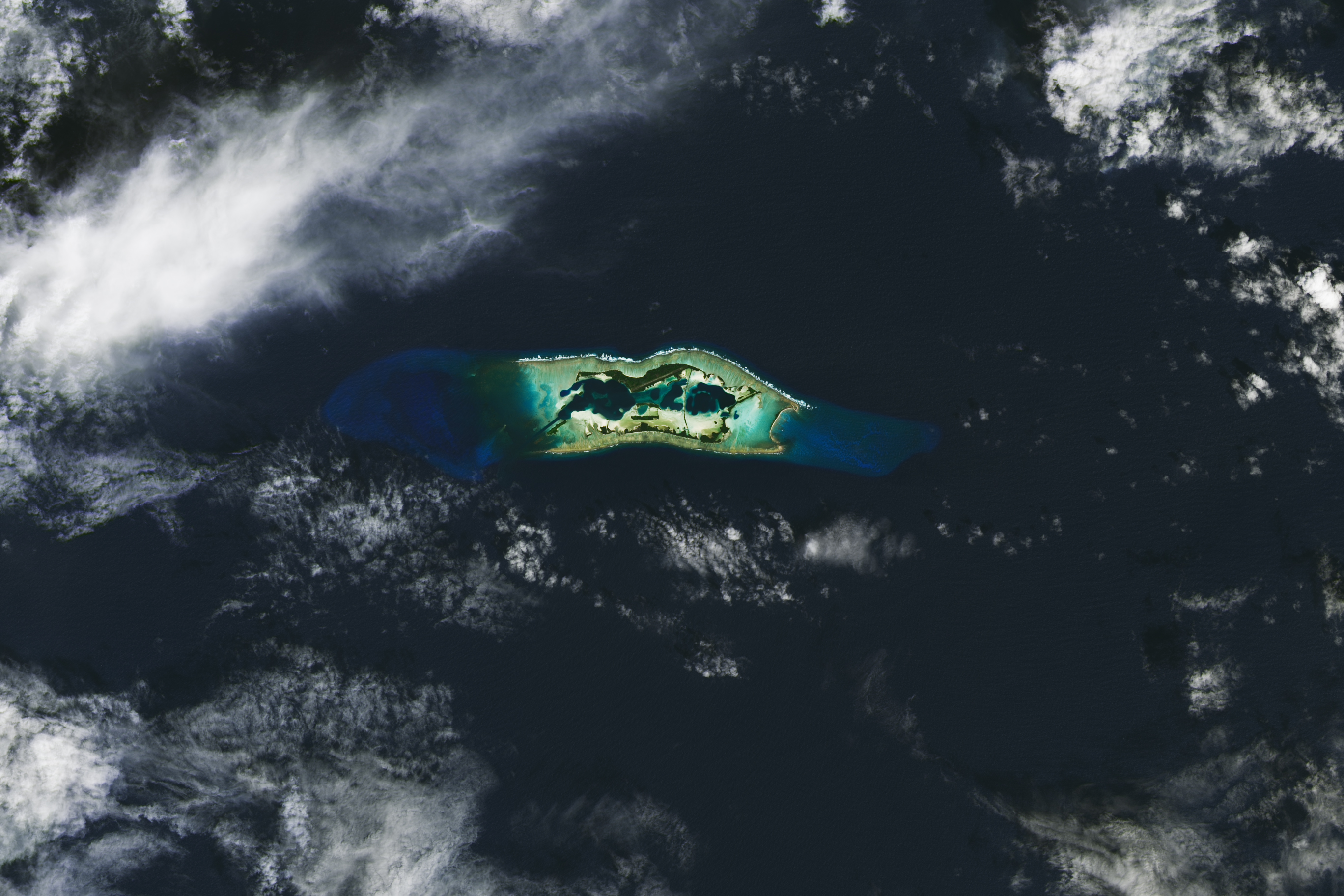
Near the geographic center of the Pacific Ocean, the Line Islands stretch across the equator along a 1,460-mile (2,350-kilometer) arc. Toward the northern end of the archipelago—about 1,000 miles south of the Hawaiian Islands—the vegetated land, sand flats, and shallow reefs of Palmyra Atoll stand out amid the tropical blue waters.
The OLI (Operational Land Imager) on Landsat 8 acquired this image of Palmyra, a U.S. marine protected area, on January 12, 2024. The atoll consists of dozens of islets and several lagoons, all encircled by a shallow reef. An airstrip and research station are visible on the atoll’s north side, on Cooper Island. No one lives there permanently, though researchers often visit to conduct field studies.
Waters and submerged lands up to 12 nautical miles (14 miles/22 kilometers) from the atoll are part of the Palmyra Atoll National Wildlife Refuge. And areas up to about 50 nautical miles (58 miles/93 kilometers) from the atoll are part of the Pacific Remote Islands Marine National Monument, which includes more than 495,000 square miles of open ocean, coral reef, and island habitats.
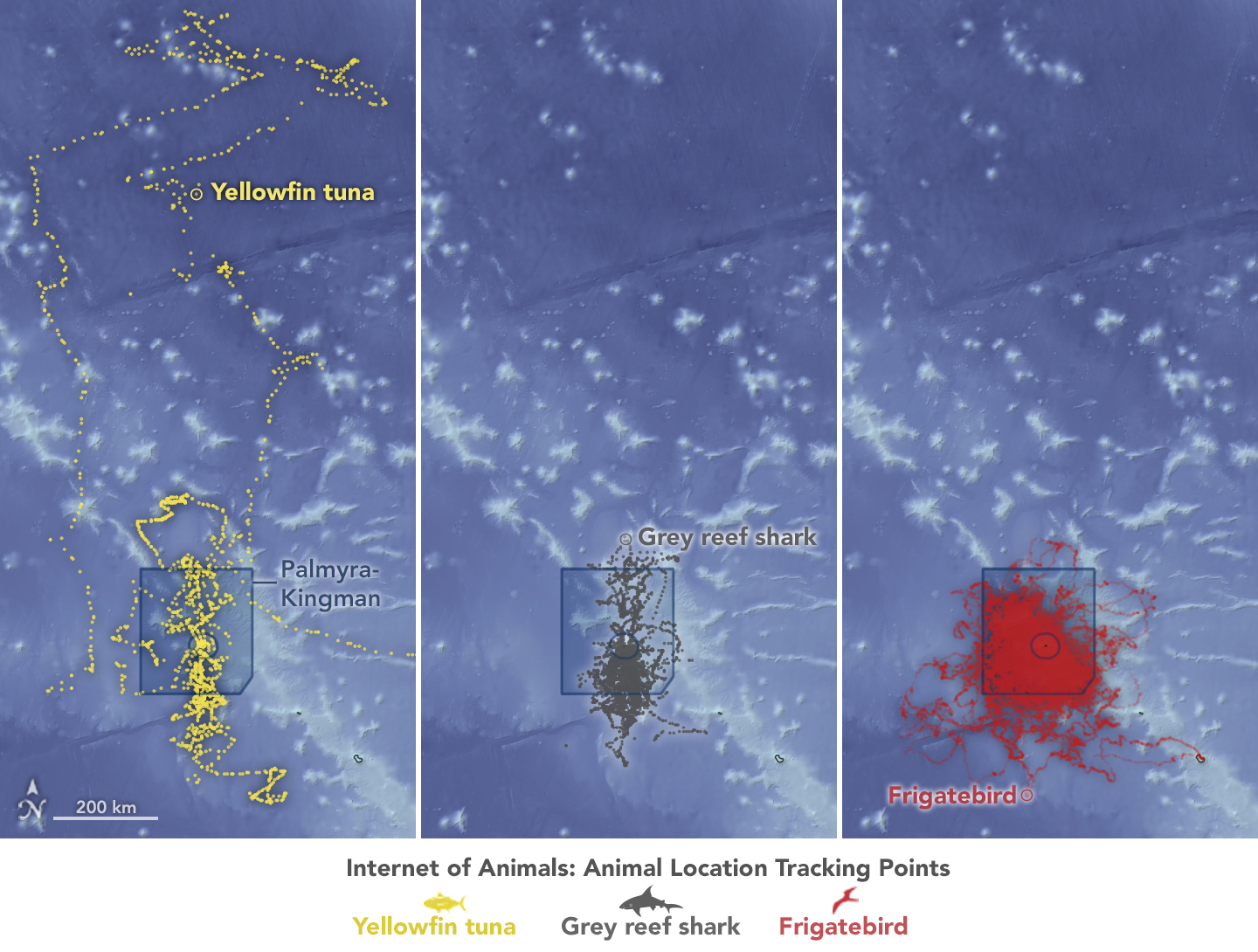
Palmyra’s remoteness, biodiversity, and protected status make it an ideal natural laboratory for researchers. One of those researchers is Morgan Gilmour, a scientist at NASA’s Ames Research Center. By analyzing the movements of animals, Gilmour and her collaborators can help assess whether the boundaries of the marine protected area surrounding the atoll protect the species they intend to, or if its limits need to shift.
Launched in 2020 by The Nature Conservancy and its partners—the U.S. Geological Survey (USGS), National Oceanic and Atmospheric Administration (NOAA), and several universities—the project team deployed wildlife tags at Palmyra in 2022, when Gilmour was a scientist with USGS.
The maps on this page show the movement in 2022 of tagged yellowfin tuna, grey reef sharks, and great frigatebirds—three of eight species that the researchers tracked at Palmyra. Notice that the animals are moving beyond the confines of the Palmyra marine protected areas (shaded on the map).
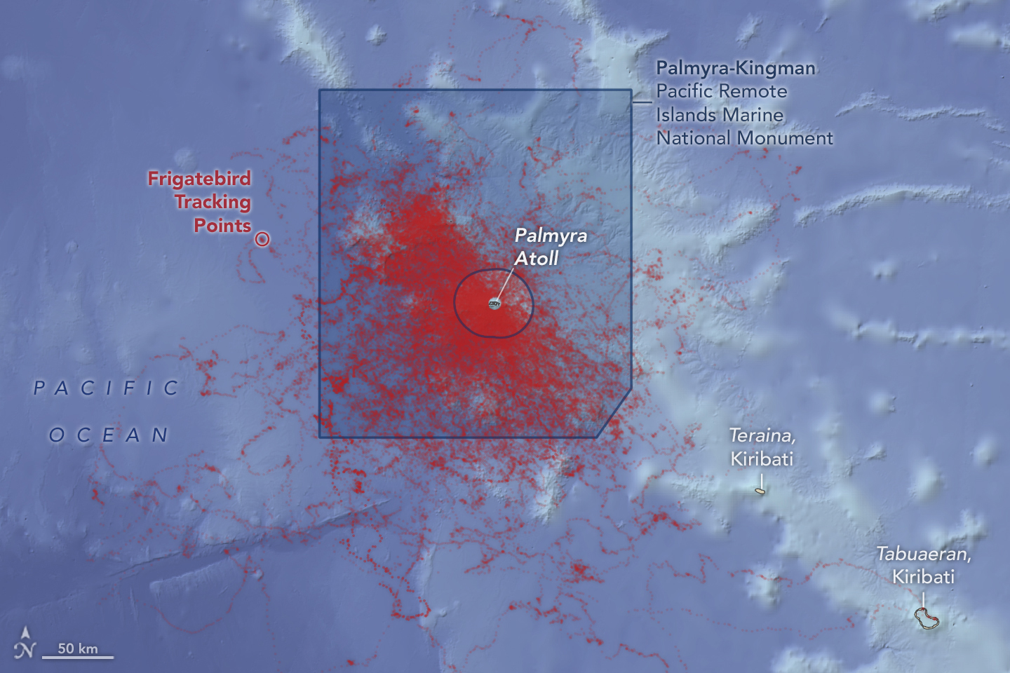
Now with NASA, Gilmour is leveraging the data for a study under the agency’s Internet of Animals project. By combining information transmitted from wildlife tags with information about the planet collected by satellites—such as NASA’s Aqua satellite, NOAA’s GOES (Geostationary Operational Environmental Satellite) satellites, and the U.S.-European Jason-3 —scientists can work with partners to draw conclusions that inform ecological management.
The NASA team put that data into a species distribution model, which combines the wildlife tracking information with environmental data from satellites, including sea surface temperature, chlorophyll concentration, and ocean current speed. The model can help researchers understand how animal populations use their habitats and how that might shift as the climate changes.
NASA Earth Observatory images by Lauren Dauphin, using animal tracking data courtesy of Morgan Gilmour/NASA and the Internet of Animals Team, Landsat data from the U.S. Geological Survey and bathymetry data from the General Bathymetric Chart of the Oceans (GEBCO). Story by Kathryn Hansen (Palmyra Atoll) and Milan Loiacono/NASA Ames (Internet of Animals).