
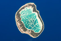
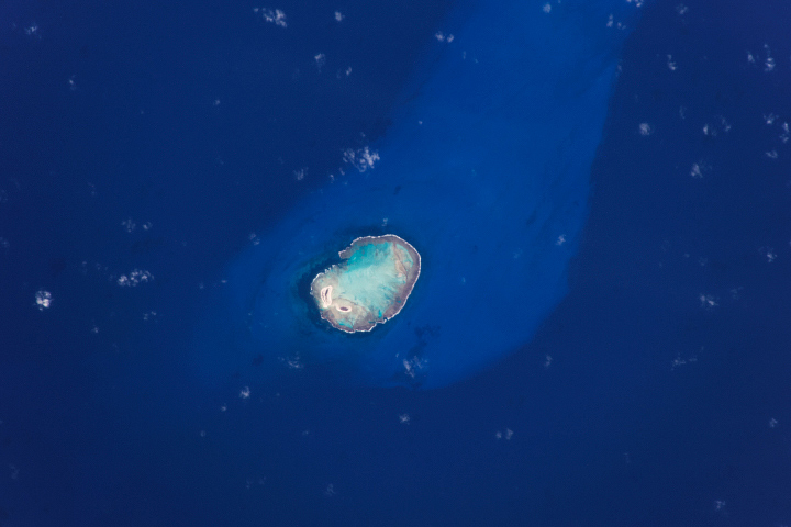
An astronaut aboard the International Space Station took this photograph of South Keeling, a remote, U-shaped atoll in the Indian Ocean comprised of dozens of coral islets.
South Keeling measures 17 kilometers (11 miles) from Horsburgh Island to South Island. North Keeling is a smaller, uninhabited atoll that lies 25 kilometers (15 miles) north of South Keeling (just outside the top-left corner of the image). South Keeling and North Keeling compose the Cocos-Keeling Islands.
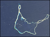
About 600 people live on two of South Keeling’s islets. Bantam Village, the atoll’s largest town, is located on Home Island. The other inhabited island, West Island, is long enough to support an airstrip, which is slightly obscured by clouds in this scene.
Astronaut photographs can reveal the relative depth of clear water. Here, the shallow water in the southern half of the lagoon appears light blue-green. This side of the lagoon can dry out when water levels are low. In contrast, the water in the northern half of the lagoon, with depths of 8 to 14 meters (26 to 46 feet), appears darker blue.
In 1836, the HMS Beagle arrived at the islands with Charles Darwin aboard. Bathymetric studies conducted during this second voyage of the Beagle supported Darwin’s general theory on how atolls develop over time.
The islands have been known by two names—Cocos and Keeling—since the 1800s. Extensive coconut palm groves led to the name “Cocos Islands.” The name “Keeling” derives from William Keeling, who was the first European to discover the islands, in 1609. The double name Cocos-Keeling became official when the islands were incorporated into Australia in 1955.
As global trade networks and colonization gathered steam, the islands became central to global communications. In 1910, prior to the First World War, a telegraph cable station was set up on Direction Island. The remote islands became a central point for communications between Australia, Southeast Asia, and southern Africa.
Astronaut photograph ISS070-E-74721 was acquired on January 19, 2024, with a Nikon D5 digital camera using a focal length of 460 millimeters. It is provided by the ISS Crew Earth Observations Facility and the Earth Science and Remote Sensing Unit, Johnson Space Center. The image was taken by a member of the Expedition 70 crew. The image has been cropped and enhanced to improve contrast, and lens artifacts have been removed. The International Space Station Program supports the laboratory as part of the ISS National Lab to help astronauts take pictures of Earth that will be of the greatest value to scientists and the public, and to make those images freely available on the Internet. Additional images taken by astronauts and cosmonauts can be viewed at the NASA/JSC Gateway to Astronaut Photography of Earth. Caption by Justin Wilkinson, Texas State University, JETS II Contract at NASA-JSC.


