The Earth Observatory has published its last Image of the Day on this website. Please join us on our new home at science.nasa.gov/earth/earth-observatory.
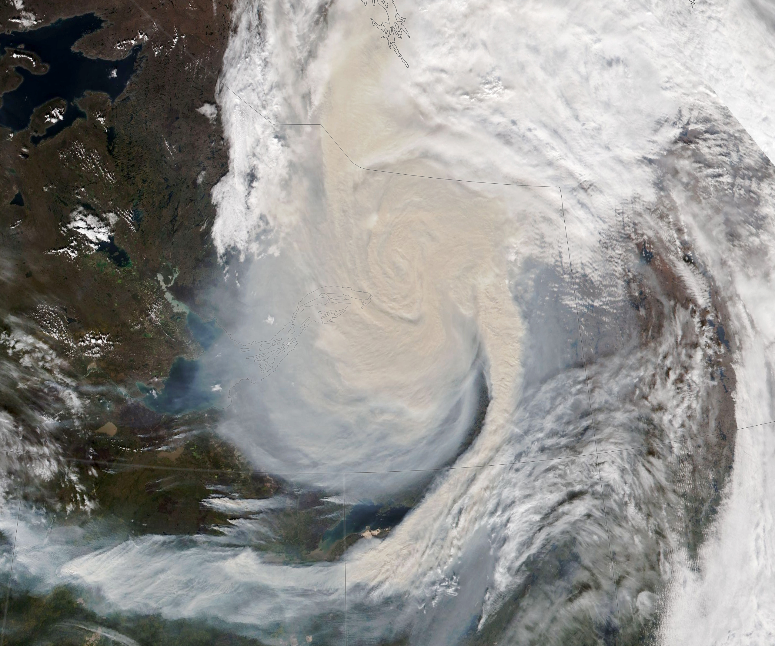
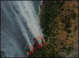
For much of summer 2023, fires burned through boreal forests in northern British Columbia and Alberta, and in the South Slave Region of the Northwest Territories. The blazes triggered evacuations as they approached towns and unleashed plumes of smoke that occasionally dipped south into the United States.
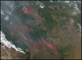
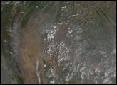
In mid-September, strong winds from a passing cold front interacted with some of the fires to create a vast smoke-infused cloud spiral. The smoky storm, which spanned hundreds of kilometers, is visible in this image captured by the VIIRS (Visible Infrared Imaging Radiometer Suite) on the NOAA-20 satellite on September 16, 2023.
The cold front carried winds with gusts as strong as 40 miles (65 kilometers) per hour. These winds intensified the fires and helped fuel towering “fire clouds” called pyrocumulonimbus (also called flammagenitus)—products of intense heat and convection—that functioned like chimneys and lofted smoke several kilometers up and into the storm clouds. Geostationary satellites captured imagery of fires east of Fort Nelson in British Columbia and another just south of Rainbow Lake in Alberta flaring up late on September 15 and sending several pulses of smoke upward, meteorologist Scott Bachmeier reported on NOAA’s Cooperative Institute for Meteorological Satellite Studies (CIMSS) Satellite Blog.
“We see dozens of pyrocumulonimbus clouds each year, but this was an impressive event,” said Colin Seftor, an atmospheric scientist at NASA’s Goddard Space Flight Center. Seftor monitors the spread of the airborne particles (aerosols) within wildfire smoke using the OMPS sensor (Ozone Mapping and Profiler Suite) on the NOAA-NASA Suomi NPP satellite.
“After the smoke was lofted up and entrained within the circulation of a passing low-pressure system, it resulted in the highest aerosol measurements we’ve seen this year,” Seftor said. “We did see two other smoke events in Canada in mid-August and early September, when aerosol index values were nearly as high,” he added.
Hiren Jethva, a Morgan State University atmospheric scientist based at NASA’s Goddard Space Flight Center, checked data collected by a lidar sensor on NASA’s ICESat-2 (Ice, Cloud and land Elevation Satellite-2) to gauge the height of the smoke plume. “ICESat-2 data show a rising smoke cloud ranging from 6 to 11 kilometers,” he said. Jethva and colleagues track smoke heights as part of a broader effort to understand how aerosols within wildfire smoke affect the radiation budget and climate when they form smoke layers above clouds.
NASA Earth Observatory image by Lauren Dauphin, using VIIRS data from NASA EOSDIS LANCE, GIBS/Worldview, and the Joint Polar Satellite System (JPSS). Story by Adam Voiland.


