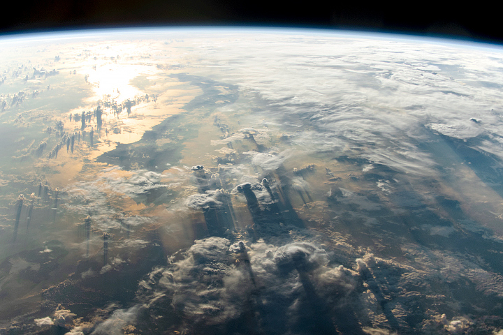
An astronaut aboard the International Space Station (ISS) took this panoramic view of a remote part of southern Africa known as the Kalahari Desert. The dark-toned lines of forest in Botswana’s Okavango inland delta are prominent against the tan landscape.
The rivers are fed by wetter regions to the north in Angola and Zambia. The Okavango River loses most of its water in the inland delta. Overflow occasionally reaches the Makgadikgadi salt flats (lower left of the image). The Zambezi and Cuando rivers reach the Indian Ocean after plunging over the Victoria Falls—a feature that has been photographed before by orbiting astronauts.
The image shows a large swath of territory from Victoria Falls on the Zambia-Zimbabwe border (lower right) to the cloud-covered Atlantic Ocean (upper left). For a sense of scale, the white salt of Etosha Pan, a dry lake, lies 960 km (600 miles) from Victoria Falls.
Smoke plumes from numerous fires in southern Angola mark the burning of savanna vegetation, which is typically comprised of grass and scattered trees. Rainfall is higher in the vegetated regions of southern Angola than farther south in Botswana’s semidesert where trees are less prolific. Fires are a normal occurrence in the dry season (winter) at the time of year this image was taken.
A field of bright, small cumulus clouds (also known as ‘popcorn cumulus’) over the valley of the Cuando River is visible in the upper right of the image. Cumulus clouds often form under conditions of sufficient local moisture in the air, combined with midday heating.
The cloud pattern over the Cuando River basin illustrates the commonly observed feature of a cloud free line tracing the course of a river. This line reflects a zone of cooler air directly above the river where cloud development is suppressed—at least on days with little wind. Similar cloud free zones above rivers can be seen in astronaut photos along the Congo River and the Rio Negro in the Amazon basin.
Astronaut photograph ISS067-E-370928 was acquired on September 17, 2022, with a Nikon D5 digital camera using a focal length of 17 millimeters. It is provided by the ISS Crew Earth Observations Facility and the Earth Science and Remote Sensing Unit, Johnson Space Center. The image was taken by a member of the Expedition 67 crew. The image has been cropped and enhanced to improve contrast, and lens artifacts have been removed. The International Space Station Program supports the laboratory as part of the ISS National Lab to help astronauts take pictures of Earth that will be of the greatest value to scientists and the public, and to make those images freely available on the Internet. Additional images taken by astronauts and cosmonauts can be viewed at the NASA/JSC Gateway to Astronaut Photography of Earth. Caption by Justin Wilkinson, Texas State University, JETS Contract at NASA-JSC.
alert message