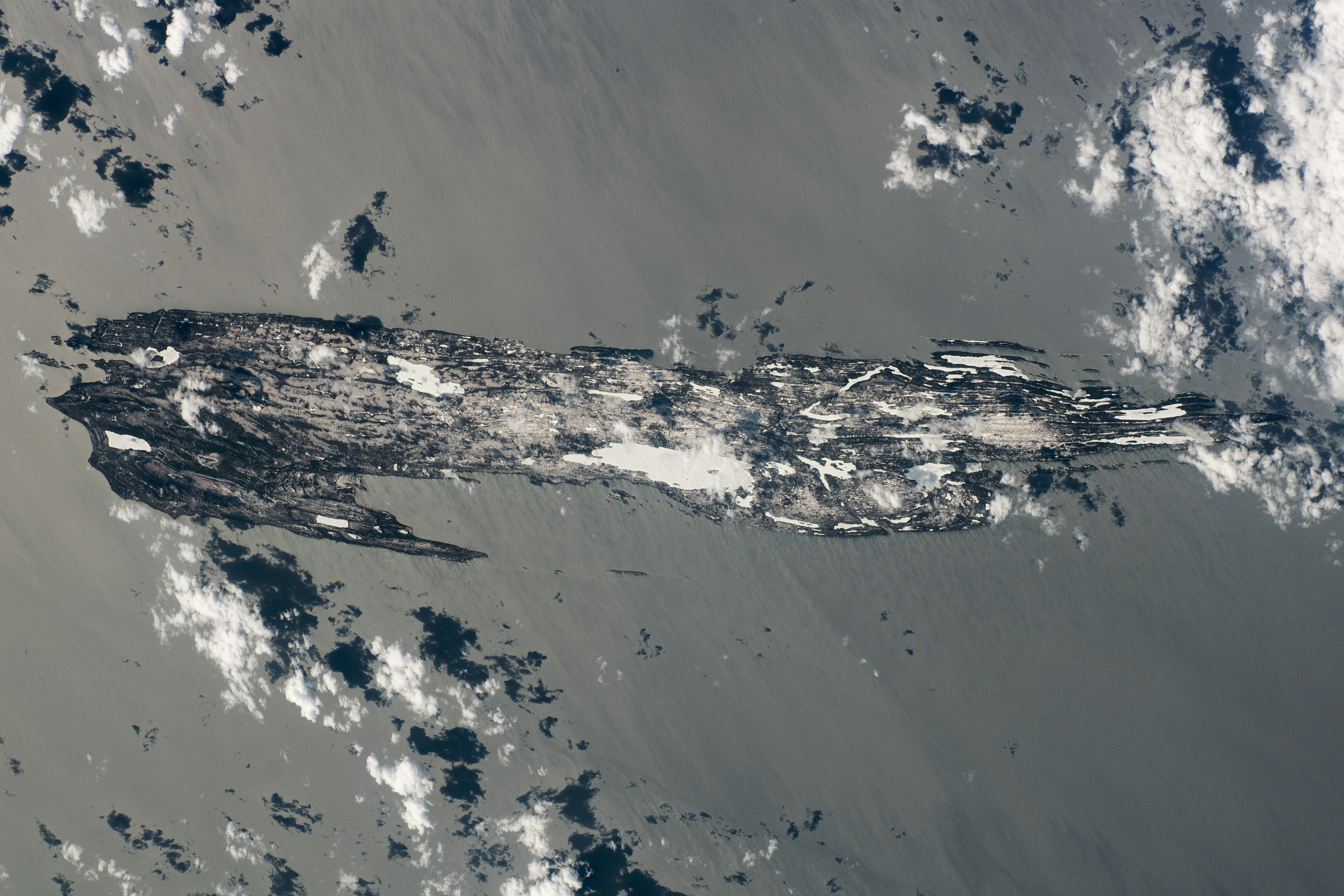
An astronaut onboard the International Space Station took this photograph of Isle Royale National Park while in orbit over the Upper Great Lakes in April 2020. At the time, the park’s islands were partially covered in snow. They are surrounded by the waters of northwestern Lake Superior—the world’s largest body of freshwater by surface area, which partially freezes each year.
Isle Royale is one of the most isolated natural areas in the continental United States and is only accessible by boat or seaplane. It is an archipelago comprised of one large island surrounded by approximately 450 smaller islands. The park spans 2,200 square kilometers (850 square miles), which includes land area and surrounding waters.
The surface geology of Isle Royale was shaped by the Greenstone lava flow around 1 billion years ago. The central topographic spine of the island is largely comprised of altered basaltic rock (greenstone) that lends its name to the Greenstone Ridge Trail. Isle Royale is part of the larger Lake Superior basin, a syncline that comprises the underlaying geology throughout the extent of the photo and stretches to the Upper Peninsula of Michigan (out of view to the bottom of the photo). Mineral-rich geologic layers partially composed of quartz, calcite, and copper are products of the region’s past volcanic activity.
In more recent geologic history, glacial events have further shaped the landscape by removing bedrock and accentuating the ridge and valley formations across Isle Royale. These glacial processes are still visible today in the form of recessed moraines, which now contain Lake Desor and Siskiwit Lake. The lakes—frozen at the time of this image—are visible near the center of the main island.
Hunting is prohibited on Isle Royale and animals only rarely migrate to and from the mainland, making the island a good natural laboratory for documenting wolf and moose populations and gaining insight into predator-prey relationships. Since 1958, ecologists have documented wolf and moose populations, genetic changes, and hunting behavior.
Through continued observation, researchers have observed fluctuations in both animal populations due to predation as well as unpredictable events such as severe winters, introduced diseases, and the migration in the 1990s of a new wolf from the mainland named “Old Grey Guy.” The project remains the longest continuous study of predator-prey ecology in the world. Observations and new insights into the complex dynamics of the natural systems are documented in annual reports.
Astronaut photograph ISS062-E-140015 was acquired on April 8, 2020, with a Nikon D5 digital camera using a focal length of 240 millimeters. It is provided by the ISS Crew Earth Observations Facility and the Earth Science and Remote Sensing Unit, Johnson Space Center. The image was taken by a member of the Expedition 62 crew. The image has been cropped and enhanced to improve contrast, and lens artifacts have been removed. The International Space Station Program supports the laboratory as part of the ISS National Lab to help astronauts take pictures of Earth that will be of the greatest value to scientists and the public, and to make those images freely available on the Internet. Additional images taken by astronauts and cosmonauts can be viewed at the NASA/JSC Gateway to Astronaut Photography of Earth. Caption by Cadan Cummings, Jacobs, JETS Contract at NASA-JSC.
alert message