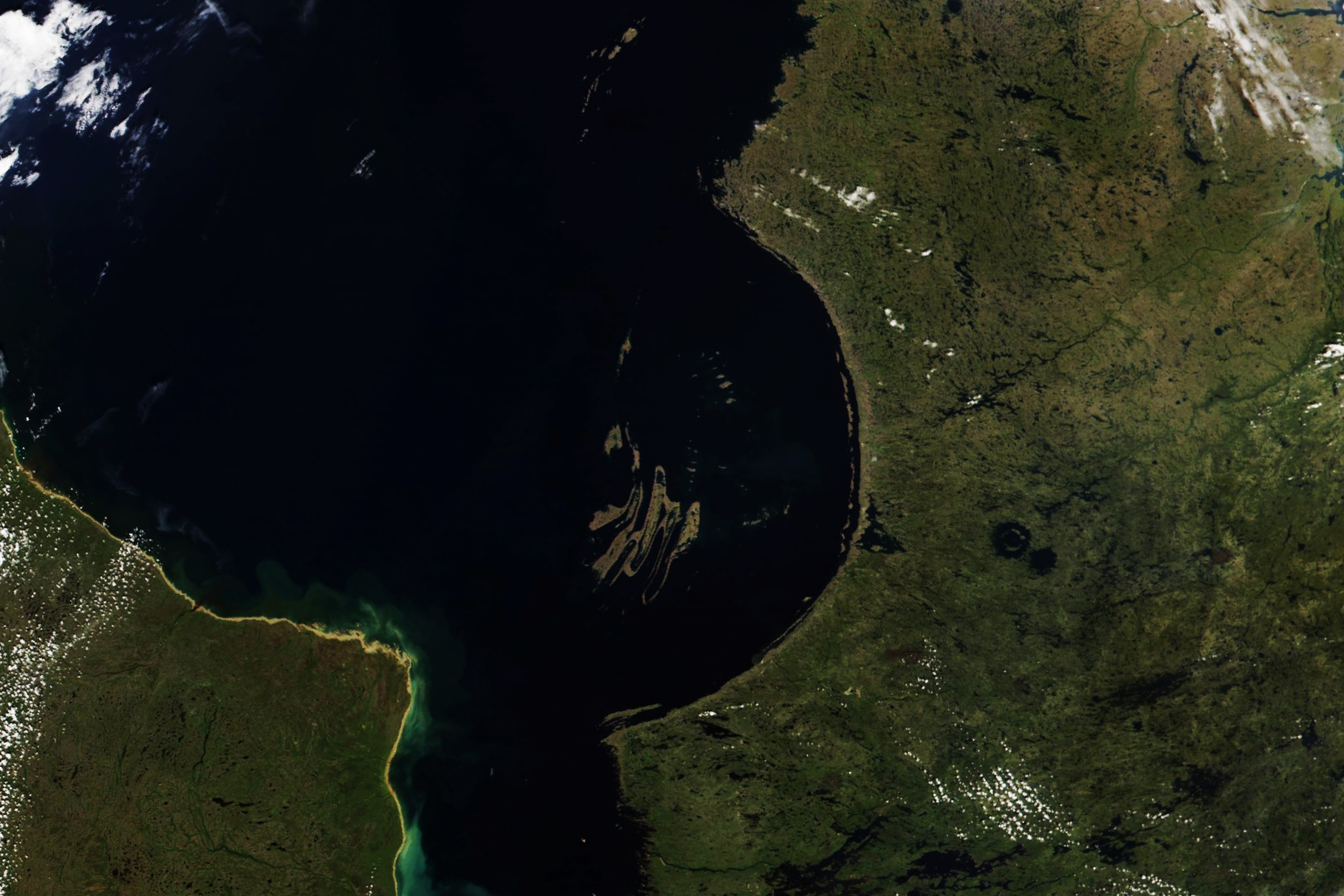
In northeastern Canada, just south of the Arctic Circle, the Hudson Bay spans more than 1.2 million square kilometers (470,000 square miles). It is the world’s second-largest bay, after the Bay of Bengal, and the site of a geologic puzzle.
The southeastern shore of the bay forms a 155-degree curve, called the Nastapoka Arc, which appears to be part of a nearly perfect circle 450 kilometers (280 miles) in diameter. The imaginary circle traces the coast of Quebec on one side and grazes the Ontario shore on the other. At its center lie the Belcher Islands. Such a smoothly curved feature is not often found in nature and has prompted much geologic debate.
This image, acquired on August 16, 2022, by the Visible Infrared Imaging Radiometer Suite (VIIRS) on the NOAA-20 satellite, shows Hudson Bay and its curved southeastern shore.
This shoreline traces the boundary between two distinct groups of rocks. Onshore, the Superior Province gneisses are hard metamorphic rocks that formed 3 billion to 2.7 billion years ago. Offshore lie the Nastapoka Group supracrustal rocks, which formed during the early Proterozoic Eon, 2.5 billion to 1.6 billion years ago.
These rock formations are part of the largest single belt of Archean-aged rocks in the world. (The Archean Eon lasted from 4 billion to 2.5 billion years ago.) They form the core of the Canadian Shield and the North American craton—the stable central core of the continent onto which other microcontinents would later accrete to build the landmass we know today. This tectonic history is key to the prevailing theory for the arc’s formation.
Geologists now generally believe the arc resulted from a continental collision—a 2-billion-year-old mountain-building episode called the Trans-Hudson orogeny. As ancient continents collided, the crust buckled and fractured into slices that could thrust past each other to accommodate the compression. This formed a fold-and-thrust belt, the remnants of which are exposed today in the folds of the Belcher Islands. Farther to the east, where the Nastapoka Arc lies today, the collision produced a foreland basin. Gravity data collected in the early 1990s suggests the load placed on the crust by the fold-and-thrust belt could have caused the center of the basin to sink, forcing up the edges, resulting in the curvature.
Other theories have also been put forth. In the late 1960s, Canadian astrophysicist Carlyle Beals suggested the arc could be the rim of an ancient impact structure, with the Belcher Islands representing the crater’s uplifted central peak. However, a field investigation in the 1970s turned up none of the usual evidence indicative of an impact, such as shocked quartz, radial fractures, melted rocks, or shatter cones.
Around that time, another researcher suggested the shoreline was a scar marking where a continent had pulled apart, or rifted. A nearby tectonic plate with a somewhat curved edge suggests it may have once fit together with the arc like two puzzle pieces.
The debate continues today. In the mid-2000s, a researcher suggested that the curving shoreline of Hudson Bay could be an ancient impact crater that has been so reworked by geologic processes that the evidence of impact has been obscured.
NASA Earth Observatory image by Lauren Dauphin, using VIIRS data from NASA EOSDIS LANCE, GIBS/Worldview, and the Joint Polar Satellite System (JPSS). Story by Sara E. Pratt.
alert message