The rains have failed in Eastern Africa for four consecutive seasons. That has not happened in 40 years of satellite records. Scientists and aid agencies are now alerting the world to an unprecedented level of food insecurity in 2022 for Ethiopia, Kenya, and Somalia. With forecasts suggesting the next rainy season will also be inadequate, climate and agriculture experts are advising governments and relief agencies to expect a significant need for food assistance.
According to a July 29 report from the international Food Security and Nutrition Working Group, the worst drought in 70 years has left more than 16 million people across the Horn of Africa coping with a shortage of drinking water. Yields of key crops are down for the third year in a row, milk production is in decline, and more than 9 million livestock animals have died or been culled due to a lack of water and suitable forage land. At the same time, regional conflicts, COVID-19, locusts, and the Ukraine War have caused price spikes and shortages of basic commodities. An estimated 18–21 million people now “face high levels of acute food insecurity” in Ethiopia, Kenya, and Somalia, the working group noted.
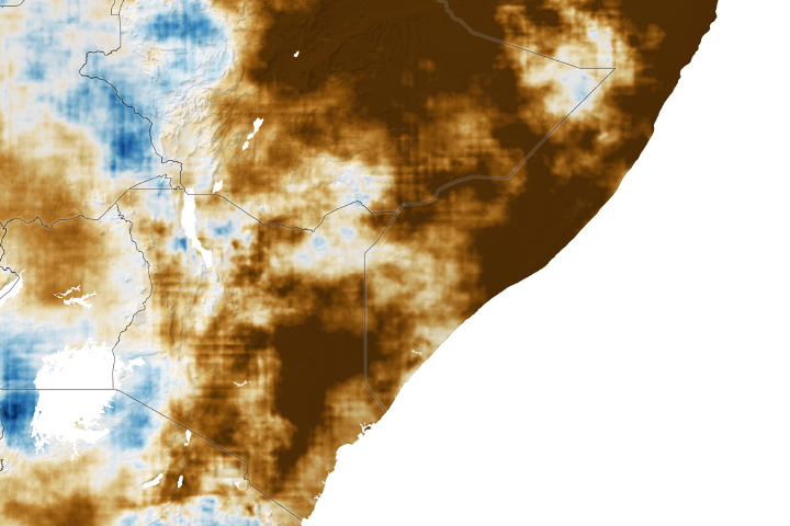
Tropical countries within the Horn of Africa tend to have two rainy seasons: the October, November, and December (OND) “short rains” and the March, April, and May (MAM) “long rains” (which sometimes extend to August in some areas). The 2020 and 2021 OND rainfall was substantially below normal, and the 2021 MAM season was also drier than normal. Then the 2022 MAM season brought the lowest rainfall on record for much of the region. At the same time, the region has endured extremely warm air temperatures that desiccate soils and evaporate already diminished water supplies.
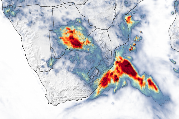
The map at the top of the page—based on the Climate Hazards Center InfraRed Precipitation with Stations (CHIRPS) dataset—shows how rainfall in March, April, and May 2022 compared to the long-term average accumulation. Areas in dark brown were well below the average rainfall for the time of year, with many areas more than 50 percent below normal.
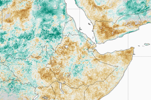
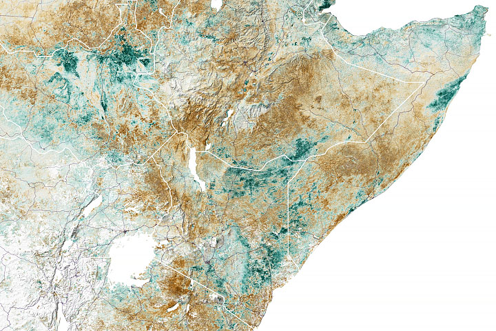
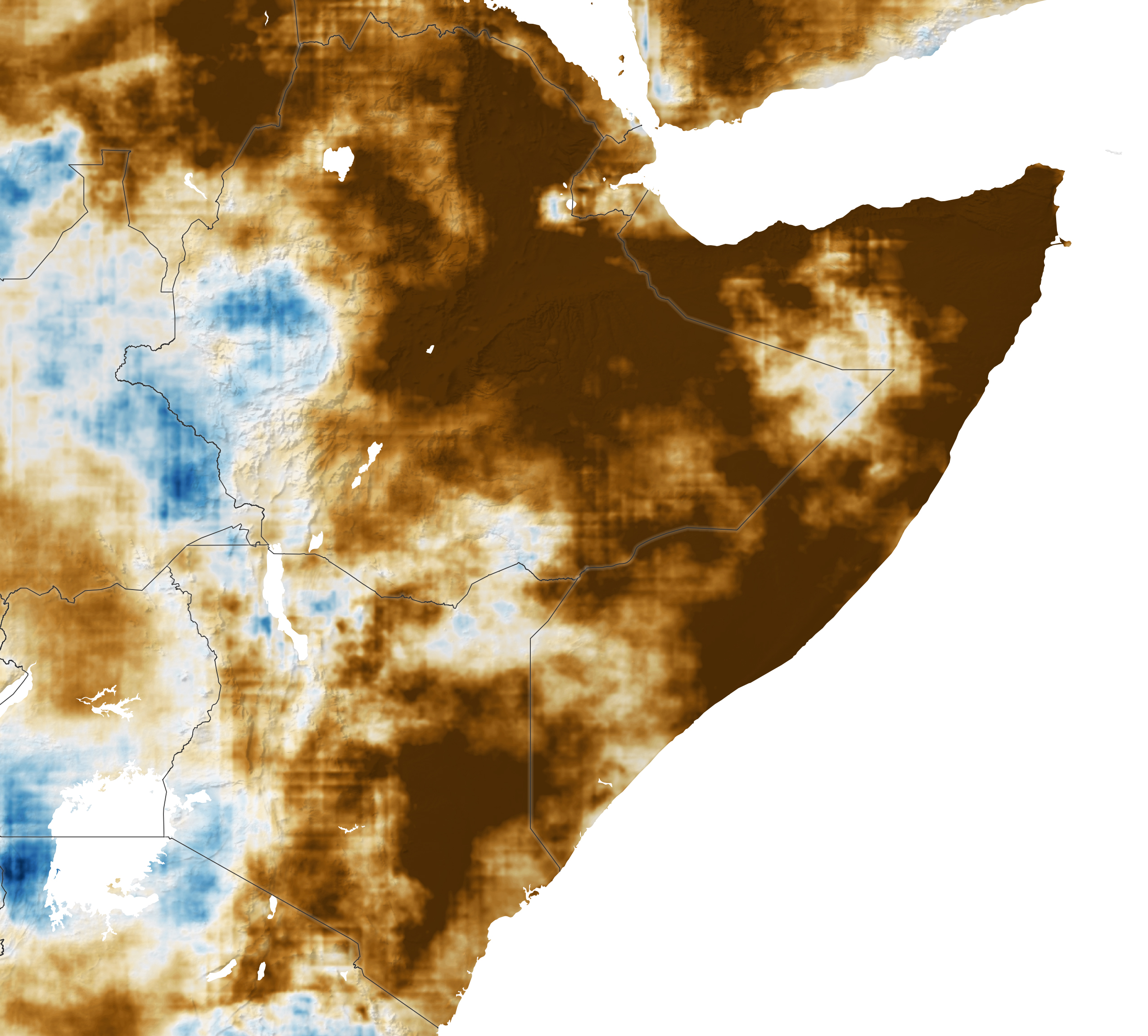
The animations above and below depict soil moisture observations and forecasts for the top meter of soil. The data come from the FEWS NET Land Data Assimilation System (FLDAS). Reds depict areas where soil moisture was below average for the day, while blues reflect areas that were above average.
The first segment of each animation shows soil moisture from August 2020 through June 2022. The last portion shows forecasts for July through December 2022, including the next rainy season. Newly planted seeds and young seedlings are highly dependent on moisture at the surface (0 to 6 centimeters). Root zone moisture (down to 1 meter) is critical for long term crop growth: As plants grow and sink roots, they are sustained by moisture in deeper layers of the soil.
The NASA FLDAS team generates and analyzes data on moisture at the land surface and in the top few centimeters of soil to show existing conditions and to predict them for upcoming months so that farmers and agriculture agencies can prepare for deficits or surpluses. The FLDAS Forecast is a custom product of the NASA Hydrological Forecast and Analysis System (NHyFAS) developed under a NASA Applied Science grant to support the Famine Early Warning Systems Network (FEWS NET).
The Horn of Africa is especially prone to drought, so FEWS NET and related agriculture and climate teams have invested significant research and modeling time into trying to predict rainfall patterns there. Scientists who study climate and weather teleconnections note that human-induced climate warming in the western Pacific, and a now-likely third year of La Niña conditions are contributing to the current drought. The La Niña cooling of the eastern tropical Pacific and the warming of the western Pacific disrupts weather patterns all over the world.
In a forecast released on August 16, the FEWS NET agroclimatology team wrote: “Sea surface temperature predictions indicate a perfect ocean for drought. There is a very high probability of both strong Indian Ocean Dipole and West Pacific Gradient conditions, and hence it is very likely that the eastern Horn of Africa will experience very poor rains and very dry soil moisture and streamflow conditions in October-November-December.” This would constitute an unprecedented fifth season of drought.
The successive rainfall deficits in eastern Africa since 2020 have had a cumulative effect: smaller crop harvests and shortages of forage; depleted water supplies for people and animals; and weakened and depleted livestock herds. While reducing food and water sources, the drought also makes it hard for citizens to earn a living from their crops and herds. On top of that, the region has not fully recovered from the losses of a deep drought in 2016–17.
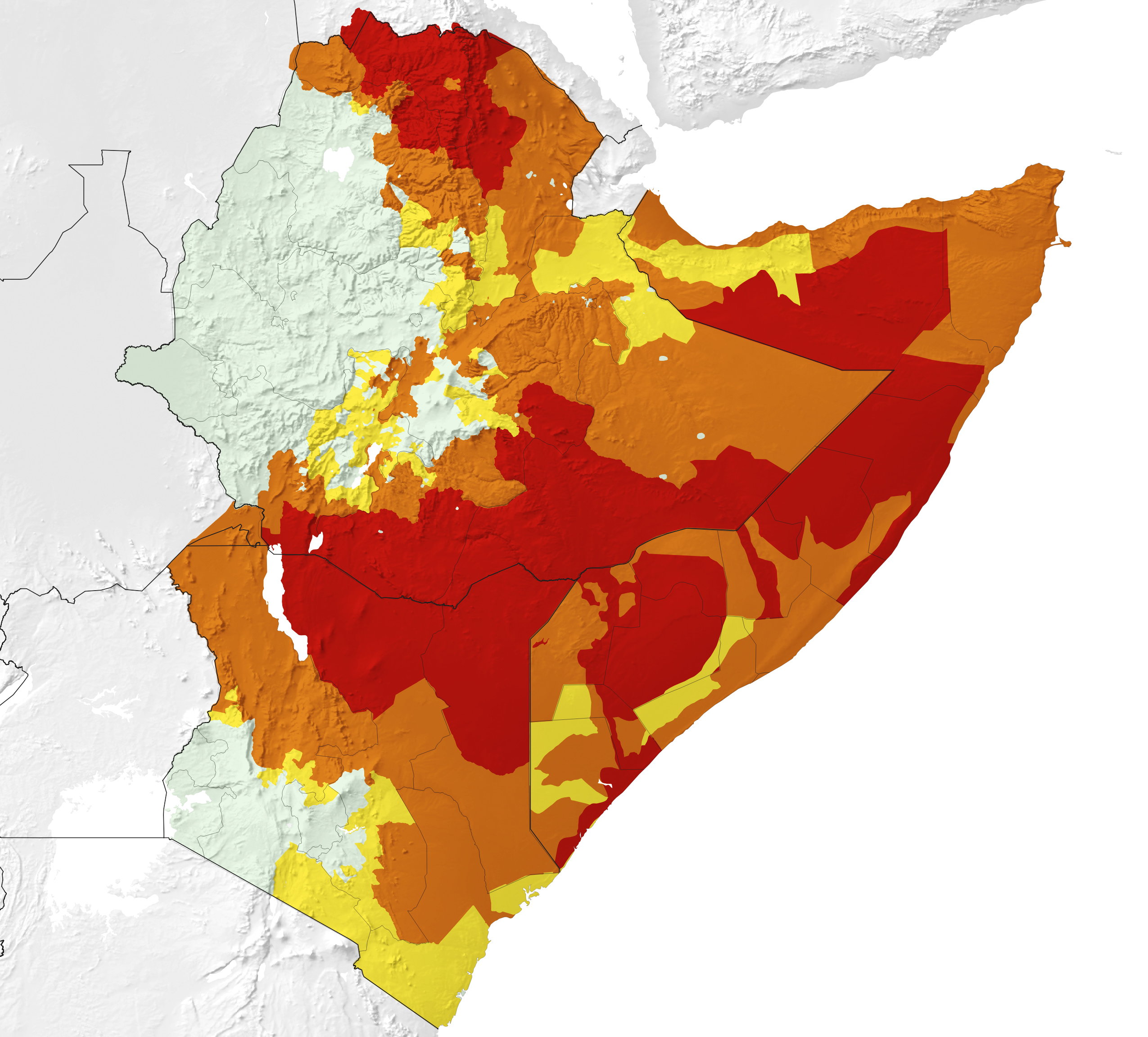
The map above, based on a data analysis by FEWS NET, shows the current levels of food insecurity across Ethiopia, Kenya, and Somalia. To describe the degree of insecurity, FEWS NET analysts use the Integrated Food Security Phase Classification, which is a standard used by the humanitarian assistance community.
Another failed rainy season in late 2022 could push the region closer to catastrophe. According to the Food Security and Nutrition Working Group, more than 560,000 children were treated for severe malnutrition between January and June 2022. If conditions continue to decline, 23 million to 26 million people could face high levels of acute food insecurity by February 2023, and 6.5 million children are projected to suffer from acute malnutrition.
The Famine Early Warning Systems Network (FEWS NET) was created in 1985 by the U.S. Agency for International Development (USAID). FEWS NET assembles global and regional analyses of food security (particularly conditions for farming and livestock husbandry) to help governments and relief agencies plan for and respond to humanitarian crises. Several U.S. agencies support FEWS NET; NASA provides satellite imagery and climate, weather, and hydrologic data.
NASA Earth Observatory maps by Lauren Dauphin, using Acute Food Insecurity Phase data from the Famine Early Warning Systems Network and rainfall accumulation data from Climate Hazards Group InfraRed Precipitation with Stations (CHIRPS). NASA animations by Trent Schindler, NASA Scientific Visualization Studio, using data from the FEWS NET Land Data Assimilation System (FLDAS). Story by Michael Carlowicz.
alert message