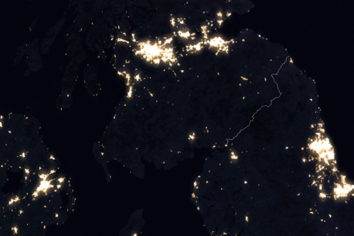
Amid the network of artificial lights lights that span our planet like a game of connect-the-dots, darkness is a precious commodity. There are places, however, where the terrain and distance from cities help keep light pollution to a minimum. Watoga State Park in eastern West Virginia is one such place.
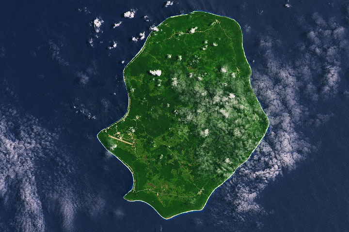
Watoga and the nearby Calvin Price State Forest and Droop Mountain Battlefield State Park combine to span a total of 31 square miles (80 square kilometers) of Pocahontas County. Located in the highlands of the Allegheny Mountains, the parks are relatively remote—far from the glow of major cities that light up much of the eastern United States. Only a handful of small towns and farms dot the otherwise heavily forested landscape.
The remoteness of the area is evident in this nighttime image, which shows the pattern of human settlement across West Virginia. The image was acquired on April 24, 2022, with the Visible Infrared Imaging Radiometer Suite (VIIRS) on the Suomi NPP satellite. The image comes from the VIIRS “day-night band,” which detects light in a range of wavelengths from green to near-infrared and uses filtering techniques to observe signals such as auroras, city lights, and reflected moonlight.
The second image (below), acquired on October 18, 2021, with the Operational Land Imager (OLI) on Landsat 8, shows a natural-color view of the parks during the daytime.
Recent changes have made the parks even darker than just a few years ago. Mary Dawson and Louanne Fatora, board members of the Watoga State Park Foundation, obtained funding that allowed them to replace existing lights throughout the park with new fixtures that aim downward and use bulbs that cause less light pollution.
In addition, volunteer astronomers tracked the quality of nighttime darkness over the span of a year, and the park held several events to educate the public about dark skies. The efforts culminated in all three parks receiving official status as “dark sky parks” in October 2021. They were the state’s first parks to receive the designation from the International Dark-Sky Association.
Even designated dark sky parks are not completely dark. Instead, they are lit by natural sources such as starlight and moonlight. The celestial light show draws amateur astronomers, stargazers, and photographers. The photograph below, shot by Jeff Ball, shows the Milky Way over Watoga Lake. The name Watoga is the Cherokee word for “starry waters,” according to the park’s website.
While dark skies are favored by stargazers, they are also important for the local ecology. “Watoga’s dark sky designation is just as much about the preservation of habitat for many unique species of animals, plants, and insects, as it is about the clarity of the night sky,” Fatora said.
For example, the park is home to the rare “synchronous” firefly. It’s the timing of their flashes—made in rhythmic, synchronized intervals—that sets their mating display apart from other fireflies. Watoga State Park is one of a handful of public locations in the United States where people can view the display. The park’s protection from light pollution should also benefit the fireflies, which are sensitive to light.
Visitors should be aware that firefly displays last just a few weeks of the summer, and celestial views are occasionally obscured by clouds. But as West Virginia’s largest state park, Watoga offers plenty of activities, such as hiking, paddling, and swimming, to keep visitors busy until the natural light shows return.
NASA Earth Observatory images by Joshua Stevens, using VIIRS day-night band data from the Suomi National Polar-orbiting Partnership and Landsat data from the U.S. Geological Survey. Photograph by Jeff Ball. Story by Kathryn Hansen.
alert message