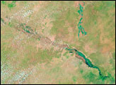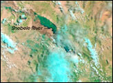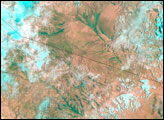

Heavy rains pounded down over the Ahmar Mountains and the desert-dry plain to their south and east on April 23 and April 24, 2005. Rivers flowing out of the mountains spread far beyond their banks on April 27, 2005, when the Moderate Resolution Imaging Spectroradiometer (MODIS) on NASA’s Terra satellite captured the top image. In these false-color scenes, water is a deep turquoise against the tan-pink desert. Clouds are light blue. Rivers that were faint spidery shadows on April 11, 2005, lower image, had become wide blue-green stokes that appeared to be hundreds of meters wider than normal on April 27, top. The region shown in this image has been plagued by drought, and that may have contributed to the flooding. Hard, sun-baked ground cannot easily absorb heavy rain, so the water tends to run off, filling depressions and riverbeds.
NASA image created by Jesse Allen, Earth Observatory, using data obtained from the MODIS Rapid Response team and the Goddard Earth Sciences DAAC.
Two days of intense rain flooded sections of Somalia and Ethiopia, pushing several rivers over their banks.


