Southeast Asia’s rainy season came to an early end in October 2004, and since that time, little rain has fallen on the Indochina Peninsula and parts of southern China. The dry spell has launched the region into the worst drought it has seen in years, with wells and reservoirs drying, crops withering, and, for some, food shortages.
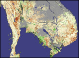
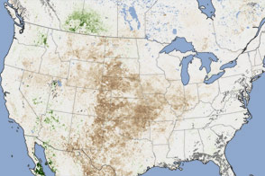
The effects of the drought are clearly visible in this image, generated from data collected by the Moderate Resolution Imaging Spectroradiometer (MODIS) on NASA’s Aqua and Terra satellites between February 18 and March 5, 2005. The image shows vegetation anomaly, a measure of plant density and health over a wide area. To determine the state of vegetation this year, the data are compared to the average of vegetation measurements collected during the same period in 2000 to 2004. Regions that are drier, where plants are less dense and healthy than normal, are brown, while areas with denser-than-average vegetation are green. In the latter half of February 2005, Southeast Asia was very dry, with plants showing clear signs of drought stress. Clouds, masked out in grey, covered much of southern China, central Vietnam, Laos, and parts of Thailand and Cambodia during this two-week period.
NASA image created by Jesse Allen, Earth Observatory, using data provided by the joint Global Agricultural Monitoring Project between NASA, USDA’s Foreign Agricultural Service (FAS), and the University of Maryland. More data and information about this joint project is available at Satellite Information for Agricultural Monitoring.