Lake Victoria is the largest lake in Africa and an economic and food security lifeline for roughly 30 million people living near its shores in Uganda, Kenya, and Tanzania. But it also takes lives. Cyclical, daily weather patterns around the lake create violent nighttime thunderstorms that kill roughly 3,000 to 5,000 fishermen per year.
“This is definitely one of the stormiest places on Earth,” said Wim Thiery, a climate scientist at the Vrije Universiteit Brussel who has studied Lake Victoria for several years. “Almost every night, you see these intense thunderstorms and sometimes even water tornadoes developing over the lake because it’s a really favorable environment for storms.”
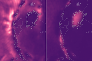
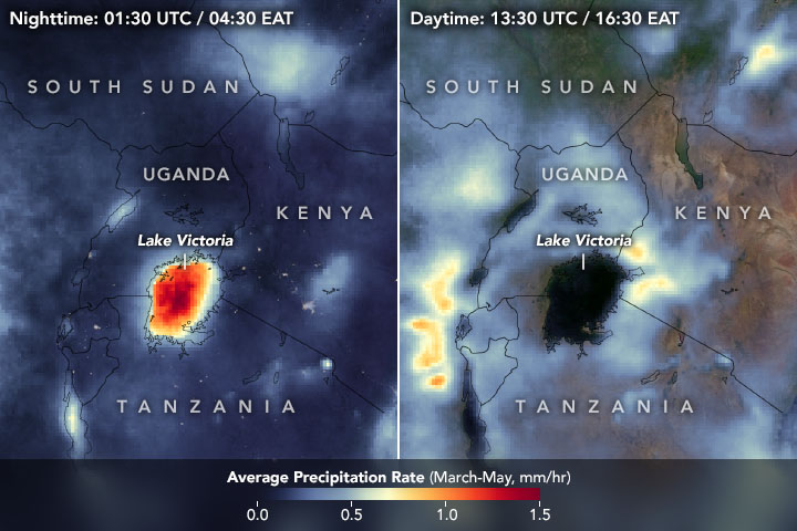
The animation above shows rainfall patterns around Lake Victoria across a typical 24-hour period during the wet season (March, April, and May). It represents the precipitation rate as calculated every half hour and averaged across 18 years (2000-2018). The data come from the newest Integrated Multi-satellitE Retrievals for GPM (IMERG) algorithm, which was released in late 2019 and provides one of the longest continuous records of high-resolution precipitation data. The IMERG product combines data from the Tropical Rainfall Measuring Mission (TRMM) satellite, which operated from 1997 to 2015, and Global Precipitation Measurement (GPM) satellite. which has been collecting data since 2014. Both missions were joint efforts between the Japanese Aerospace Exploration Agency (JAXA) and NASA.
“Having nearly a 20-year record helps us focus on average long-term patterns, as opposed to year to year variability,” said Jackson Tan, a researcher with USRA at NASA’s Goddard Space Flight Center who recently published a paper on the latest IMERG product. “A longer record is more representative of a region’s climatology.”
The diurnal weather pattern near Lake Victoria is generally characterized by afternoon storms over surrounding land and intense nighttime storms over the lake. The storms are due to a combination of the lake's location, size, and nearby topography. Similar day-night storm patterns also appear over the lakes surrounding Lake Victoria, but are less pronounced due to their smaller size.
“We don't have too many large lakes located across the tropical belt like Lake Victoria to observe this weather behavior,” said Kris Bedka, a climate scientist at NASA’s Langley Research Center. “Lake Victoria is special because these storms are so repetitive and a daily occurrence during some times of the year.”
In general, thunderstorms here form through the interaction of cold and warm air masses. Daytime breezes flow from the relatively cool surface of Lake Victoria toward the hotter, sun-baked land. The warm air over the land rises higher into the atmosphere; as it cools, water vapor condenses into small water droplets and clouds. The cooled air sinks lower in the atmosphere to compensate for updrafts. If this cycle of rising and sinking air—or process of convection— is intense, it can create a thunderstorm. The thunderstorm continues to develop as long as it has warm air fueling it from below.
In the animation, precipitation peaks over land at around 4:30 p.m. (16:30) local time, when thunderstorms are typically most active due to afternoon surface heating from the Sun. Rainfall is particularly apparent to the northeast and west of Lake Victoria, where mountain ranges also help drive the upward motion of warm air masses.
The process reverses at night. When the Sun goes down, the land cools but Lake Victoria stays warm (water retains heat longer than land). The temperature difference between the lake and the air over the land causes breezes to develop and blow toward the lake. When the wind-driven air masses converge over the lake, they rise in the convection process that triggers thunderstorms.
“The lake is a repository of moisture, and it’s really hot and humid. But you need the uplift of warm air to trigger a thunderstorm,” said Bedka. “The converging air flows set things in motion.”
“We are actually able to predict a lot of these extreme nighttime thunderstorms by looking at the afternoon conditions on land,” said Thiery, who co-authored a study with Bedka that demonstrated the ability to predict the nighttime storms. “We discovered that the intensity of storms occurring during the afternoon can tell us something about what we can expect at night over the lake.”
According to Thiery and Bedka, stronger afternoon storms lead to stronger nighttime storms. As Thiery explained, afternoon thunderstorms bring more rain and moisture over land. When the breezes blow from the land toward the lake at night, they carry that extra moisture, which provides more fuel for thunderstorms. The afternoon thunderstorms also cool the land surface, which creates an even larger temperature difference between the land and lake, leading to stronger land breezes at night.
“Having this precipitation data sampled every half hour, we're able to see storms grow and propagate across the lake,” said Bedka. “You would never know or understand this complete process unless you had this frequent sampling across such a long data record.”
NASA Earth Observatory images and video by Joshua Stevens, using Global Precipitation Measurement (GPM) Mission data courtesy of Jackson Tan/USRA/NASA/GSFC. Story by Kasha Patel.