On September 28, 2018, a powerful, shallow earthquake ruptured the land surface and seafloor near Indonesia’s Sulawesi island and sent a devastating tsunami into the city of Palu. While the nearby strike-slip fault was a known tsunami hazard, the magnitude 7.5 earthquake surprised scientists because it triggered large and deadly landslides in an area with a gently sloping landscape.
One year later, a team of scientists from six countries has unraveled the mystery of the landslides and discovered a new earthquake hazard in the process. Examining various types of radar and visible satellite data, the team found that mud and soil flowed most readily near irrigated rice paddies.
The practice of keeping farmland soaked for rice cultivation slowly draws the water table—the layer below ground where the soil becomes saturated—closer to the land surface. This makes the soil wetter and more prone to liquefaction—the process by which sandy soils behave like a liquid in response to strong ground shaking. As shaking overpowers the friction that normally holds particles together, soil loses its structural integrity and begins to flow like a liquid. It can act like a lubricated surface, allowing relatively solid ground to slide freely downslope under the force of gravity.
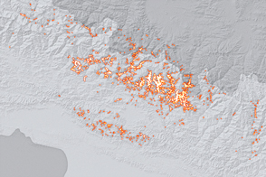
Soil liquefaction usually occurs in flat landscapes with sandy or silty ground, such as coastal plains where the water table is close to the surface. While Palu has sandy soil, the gently sloping valley around the city appeared to pose little risk as high water tables are rare on hillsides. But when researchers began to examine damage after the Palu quake, they noticed that all the landslides originated along a distinct line and near an aqueduct. “We started studying why the aqueduct so clearly defined the boundary between land sliding and not sliding,” said Sang-Ho Yun, a natural disasters researcher at NASA’s Jet Propulsion Laboratory.
The image above is a damage proxy map created by Yun and colleagues. They examined satellite radar data collected before and after the quake, mapping changes in the land surface and built structures. Yun’s data has been overlaid on a digital elevation map to show the slope of the landscape.
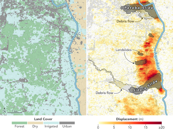
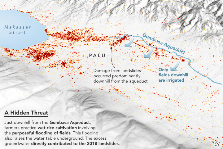
The maps above were made from data provided by Kyle Bradley of Nanyang Technological University. Provoked by damage maps, Bradley and colleagues gathered land-cover maps plus visible satellite imagery taken by the commercial satellite company Planet just before and after the earthquake in order to determine where and why the land deformed and slid. They used software to calculate horizontal land displacement, particularly in areas around the aqueduct.
The Gumbasa Aqueduct was built in the early 20th century on the east side of Palu to reduce the risk of famine by providing a consistent water supply to local farmers. Only the land downhill from the aqueduct is irrigated. Farmers just below the aqueduct practice wet rice cultivation, in which fields are flooded at one point in the growing cycle. Farther downhill, near Palu, farmers grow tree crops like coconut palms, which require less irrigation and do not raise the water table as much.
Despite slopes of no more than 1.5 to 2 degrees, the earthquake caused land to slide as much as 1 kilometer. The cause was widespread liquefaction in the irrigated rice paddies below the aqueduct. (No liquefaction was identified upslope of the aqueduct, where the water table was closer to its natural level.) Because the aqueduct did not have an impermeable lining, it is likely that leakage also played a role. The slides were slowed or halted by the coconut palm plantations.
“If there hadn't been intensive irrigation, the landslides and the resulting damage and loss of life probably would not have happened,” said Bradley, the lead author on the paper. “This was a human-caused hazard, and it can have a human solution. We cannot directly reduce the hazard of ground shaking on Palu, but the agricultural practices can be updated to reduce the human exposure to this hazard.” For instance, farmers could plant more trees near their rice fields in order to better anchor the soil and draw down the water table.
The findings from Palu have Bradley and colleagues considering whether agricultural practices have played a role in other landslides or could be creating new seismic hazards elsewhere. Indonesia is not the only place in the world where people grow heavily irrigated crops on wet, sandy slopes. “There are a few historical cases where earthquake-triggered liquefaction seems to have been strongly correlated with irrigation, and cases where major slope failures and landslides were related in some way to irrigation,” Bradley added. “This is likely to be a problem where irrigation practices are inefficient and excess groundwater exists. However, any tectonically active location with sandy soils, a surface slope, and a raised water table are of concern.”
NASA Earth Observatory images by Joshua Stevens, using data courtesy of Bradley, K. et al. (2019) and topographic data from the Shuttle Radar Topography Mission (SRTM). Story by Michael Carlowicz, with reporting from Esprit Smith and Carol Rasmussen, NASA Jet Propulsion Laboratory, and Shireen Federico, Nanyang Technological University.