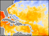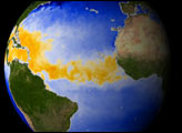
This image of sea surface temperature was acquired by the AMSR-E instrument aboard NASA’s Aqua satellite on September 6, 2004. AMSR-E is a satellite microwave sensor capable of accurately measuring sea surface temperature through clouds.
For years scientists have known there is a strong correlation between sea surface temperature and the intensity of hurricanes. But one of the major stumbling blocks for forecasters has been the precise measurement of those temperatures when a storm begins to form. In this image the cross hairs represent the position of France’s eye at 21:00 UTC (5:00 PM EDT) each day. The ocean surface has been falsely colored to show a map of water temperature—light blues are about 25C, oranges are about 28C, and reds are roughly 31C.
A hurricane gathers energy from warm waters found at tropical latitudes. In this image we see a representation of Hurricane Frances crossing the Atlantic, leaving a cooler trail of water in its wake (light blue areas within the orange areas). Strong storms like Hurricane Frances easily churn up the tropical waters bringing deeper, cooler water to the sea surface.
AMSR-E was provided to the Aqua program by the Japanese Aerospace Exploration Agency (JAXA).
Sea Surface Temperature data from the Advanced Microwave Radiometer for EOS (AMSR-E), courtesy Remote Sensing Systems.
alert message