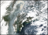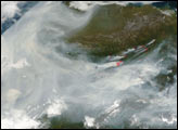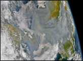

The total acres burned in Alaska so far in 2004 have surpassed the previous record set in 1957, making this the worst year for Alaska fires since officials began keeping records. This year’s fires have been driven by unusually hot and parched weather and numerous lightning strikes. Fire activity in the state of Alaksa decreased towards the end of July, as the region began to receive some much-needed rain. However, fire activity started to increase again in mid-August. See Fires in Alaska.
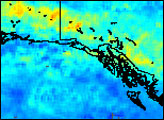
In addition to smoke and other pollutants, fires produce carbon monoxide, which is measured by the Measurements of Pollution in the Troposphere ( MOPITT) instrument onboard NASA’s Terra satellite. The image above shows the concentrations of carbon monoxide at about 3 km (700 mbar) in the atmosphere from MOPITT data collected between August 10 and August 20, 2004. Red and yellow indicate high concentrations of carbon monoxide. The data reflect the large amount of pollution that is produced by fires in Alaska and Canada and is being transported towards the east and southeast.
Data courtesy of the NCAR and University of Toronto MOPITT Teams
Smoke from large forest fires in Alaska has made the rounds across several parts of the Northern Hemisphere since the fires began in mid-June 2004. In this scene, smoke is spreading southward along the western arc of the Alaska Range Mountains and the Alaska Peninsula.


