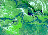
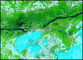
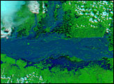
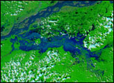
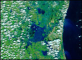
Weeks of intense heat in India finally gave way to a late-onset monsoon season, and the people in the sate of Assam in the northeast part of the country traded one environmental insult for another: heat for flooding. A deluge of rain brought the Brahmaputra River and numerous tributaries out of their banks in severe flooding that has displaced almost half a million people. These images show the region on March 5 (top images, before the monsoon) and June 16 (bottom image, monsoon flooding). Both images were acquired by the Moderate Resolution Imaging Spectroradiometer (MODIS) on the Aqua satellite.
The top two images are from March 5, showing the wider area and a close up of the Brahmaputra River in Assam using a false-color image technique that highlights the presence of standing water, which appears dark blue or black. The river makes a thin squiggly line through the pale tan flood plain, which contrasts against the green vegetation. On June 16 (bottom image), the swollen river makes a broad blue line through the image, and flooded areas are obvious all along the foothills of the Himalaya Mountains, which run across the top of the images.
The high-resolution image provided above is 500 meters per pixel. The MODIS Rapid Response System provides this image at MODIS? maximum spatial resolution of 250 meters.
Image courtesy Jacques Descloitres, MODIS Rapid Response Team at NASA GSFC