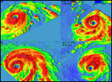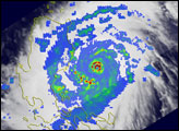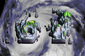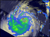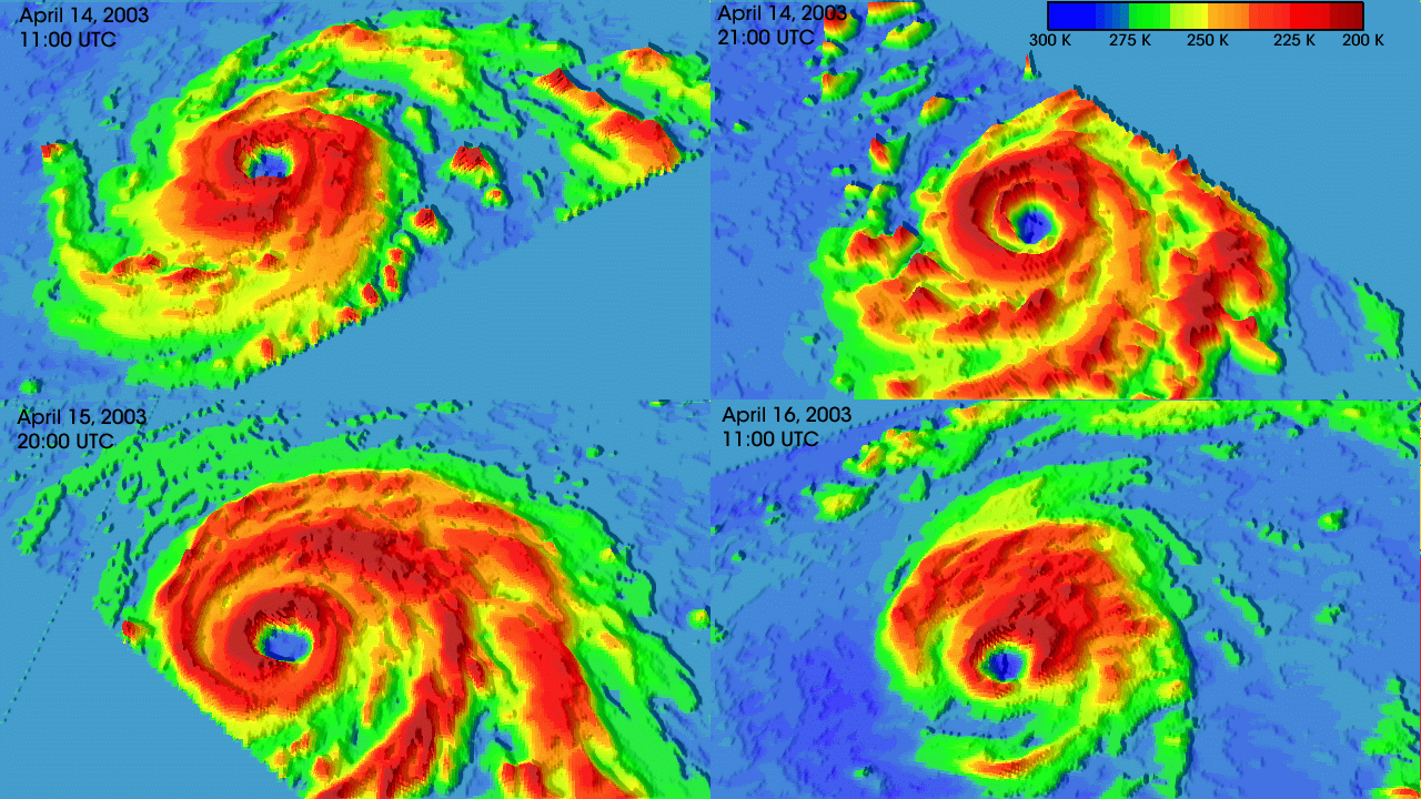
This remarkable mosaic was obtained from the TRMM Microwave Imager (TMI) and shows the evolution of Super Typhoon Kujira's eye in the Western Pacific during April 14-16, 2003. The storm, located over open water well to the north of Papua New Guinea, was steadily intensifying during the period of TRMM observations, and achieved maximum sustained winds of 130 knots. The dates and times of these images are as follows: Upper left (April 14, 11:00 UTC); upper right (April 14, 21 UTC); bottom left (April 15, 20 UTC); and bottom right (April 16, 11 UTC). Earth's natural microwave energy upwelling from the lower layers of the atmosphere passes through clouds unimpeded, but is partially blocked by large precipitating ice particles (such as snowflakes) high in deep clouds. The TMI measures the amount of energy scattered by the ice particles. The more ice there is, the more energy is scattered, meaning smaller amounts of energy are received by TRMM. Low values of returned energy (200 degrees Kelvin, shown by the color scale) represent the most intense clouds (colored red on the image). The dark blue color in the center of the eye signifies very warm temperatures and (essentially) the absence of any ice-producing clouds. In addition to adding artificial color, the energy values have been rendered in terms of three dimensions, with the coldest, tallest clouds rising above all others. Thus, the eyewall appears as a tall ring of deep, intense convective clouds at the center of the storm.
By following the sequence of images, we can watch the structure of the eyewall change with time. Initially on April 14th, Kujira's eye is quite symmetric and very circular. It's "healthy" appearance signifies continued intensification. But only a few hours later on the 14th (top right panel), the storm's circulation evolves into several heavy rainbands. More interestingly, the eyewall appears to assume a double structure, with a partial eyewall ring embedded within the larger outer eyewall. Very powerful tropical cyclones such as super typhoons frequently undergo one or more of these "eyewall replacement cycles," where a new eyewall develops and replaces an existing one. When this happens, the intensity of the tropical cyclone can dramatically fluctuate. The lower left panel (15 April) shows the super typhoon during its mature stage, and a single eyewall is again present. The extent of the circulation has also greatly expanded, with broad rainbands wrapping in from the south. However, on the 16th (lower right panel), the storm's circulation is finally beginning to weaken; marked by the disappearance of rainbands in the southeast quadrant and an asymmetric eyewall. Loss of a contiguous eyewall usually heralds a decrease in storm intensity.
Like a CAT Scan, TRMM peers through the clouds and shows us the evolution of a powerful typhoon in Pacific, with the associated structural changes that signify intensification, peak intensity and weakening phases over a multi-day period.
animations
ÿÿsmall (379 KB)
ÿÿlarge (1.7 MB)
These images were created by Hal Pierce of the NASA Goddard Space Flight Center. More information on TRMM can be found at trmm.gsfc.nasa.gov