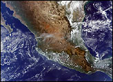
Set against the sapphire blue waters of the Pacific Ocean and Gulf of Mexico, central Mexico boasts a dazzling array of colors and landscapes, from verdant green tropical forests to black mountains to caramel-colored, high-altitude deserts. The Sierra Madre Occidental Mountains march down the western portion of Mexico, while the Sierra Madre Oriental Mountains march down in the east. Mexico City, the country's capital, sits in a small valley to the right of the image center, and is very near three small fires, marked in red. To the left of Mexico City is the city of Toluca, which appears as a small, dark gray smudge. Far to the west, north of the Laguna de Chapala (left of center), is the city of Guadalajara, which appears grayish brown against the southern reaches of the darker, brown-black Sierra Morone Mountains.
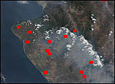
MODIS detected a number of fires scattered through a few Mexican states, mostly in Guanajuato and Michoacan (slightly left of center). Air pollution, both from fires and anthropogenic sources, is also quite visibly casting gray-blue palls over portions of the country. It is especially noticeable along the image’s northeastern coast, where it obscures much of the land beneath and almost completely hides the Laguna de Tamiahua on the bit of land jutting eastward into the Gulf of Mexico. Rather than spreading over the whole country, the pollution in the northeast is contained by the Sierra Madre Oriental Mountains and is blown out over the Gulf. This true-color Terra MODIS image was acquired December 4th, 2002.
Image courtesy Jeff Schmaltz, MODIS Rapid Response Team, NASA GSFC