Hurricane ClimatologyThe number of hurricanes occurring annually on a global basis varies widely from ocean to ocean. Globally, about 80 tropical cyclones occur annually, one-third of which achieve hurricane status. The most active area is the western Pacific Ocean, which contains a wide expanse of warm ocean water. In contrast, the Atlantic Ocean averages about ten storms annually, of which six reach hurricane status. Compared to the Pacific Ocean, the Atlantic is a much smaller area, and therefore supports a smaller expanse of warm ocean water to fuel storms. The Pacific waters also tend to be warmer, and the layer of warm surface waters tends to be deeper than in the Atlantic. The frequency and intensity of hurricanes varies significantly from year to year, and scientists haven’t yet figured out all the reasons for the variability. 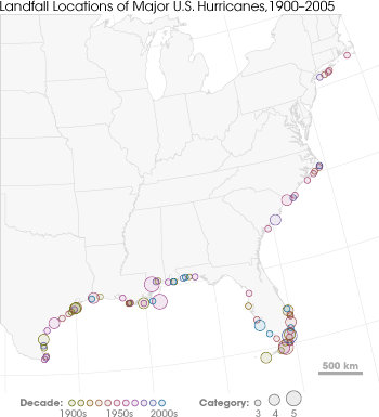
This map shows major hurricanes (Category 3 or higher) making landfall in the United States since 1900. The hurricane landfall locations are marked with circles: Color indicates the year, and size indicates the hurricane’s intensity (Category 5 is the biggest). Southern Florida and the Gulf coasts of Louisiana and Texas experience the most frequent and intense hurricanes. (Graphic by Robert Simmon, NASA GSFC.) Hurricanes and El NiñoScientists continue to investigate the interactions between hurricane frequency and El Niño. El Niño is a phenomenon where ocean surface temperatures become warmer than normal in the equatorial East Pacific Ocean. In general, El Niño events are characterized by an increase in hurricane activity in the eastern Pacific and a decrease in activity in the Atlantic, Gulf of Mexico, and the Caribbean Sea. During El Niño years, the wind patterns are aligned in such a way that there is an increase in vertical wind shear (upper level winds) over the Caribbean and Atlantic. The increased wind shear helps to prevent tropical disturbances from developing into hurricanes. Oppositely, in the eastern Pacific, El Niño alters wind patterns in a way that reduces wind shear, contributing to more storms. Hurricanes and Global WarmingSince warm ocean waters and warm, moist air fuel storms, theory predicts that global warming should increase the number and intensity of tropical cyclones. As the oceans soak up extra heat from the atmosphere, ocean surface temperatures rise, increasing the extent of warm water that can support a hurricane. Not only should this mean that more hurricanes can form, but increased ocean surface temperatures could also increase a storm’s maximum potential intensity, the strongest a storm can get in ideal conditions. Models based on scientists’ current understanding of hurricanes suggest that if ocean temperatures increased by 2-2.5 degrees, the average intensity of hurricanes would increase by 6 to 10 percent. Since 1970, the average ocean temperature has warmed about half a degree, which means that theoretically, storms could be one to three percent stronger. Such an increase translates to a few knots in wind speed, too small a change to accurately measure. Hurricane wind speeds have historically been measured in increments of five knots, so any increase in intensity that has already occurred as a result of global warming would, in theory, be too small to detect yet. However, in 2005 and 2006, several studies suggested that global warming may be impacting hurricanes more than theory predicts. In an analysis of the historical record, there appeared to be an increase in the number of intense (Category 4 and 5) storms in recent years. Another analysis charted sea surface temperatures and the number of tropical cyclones. It revealed that as sea surface temperatures went up, the number of cyclones went up. Was the increase in sea surface temperatures responsible for the increased number of storms or did some outside factor drive both? 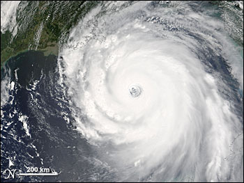
Hurricane Katrina made landfall on August 28, 2005. The Moderate Resolution Spectroradiometer (MODIS) on NASA’s Terra satellite took this picture as the hurricane approached the Gulf Coast. Hurricane Katrina sparked public and scientific debate about the role of global warming in hurricane frequency and intensity. (NASA image courtesy the MODIS Rapid Response Team at Goddard Space Flight Center.) The studies triggered many questions. Both theory and the studies suggested that there should be a link between global warming and hurricanes, but the studies showed a much greater increase in storm frequency and intensity than theory predicted. What caused the discrepancy? Is humanity’s current understanding of hurricanes flawed? Can the theory be adjusted to explain why hurricanes would have a stronger reaction to warming than previously predicted? One theory put forth to explain the recent increase in storm intensity and frequency in the Atlantic basin is the multi-decadal oscillation. Storms in the Atlantic may go through a natural cycle of 20-30 years of increased activity followed by a quieter period. The record seems to show such a cycle, with more intense hurricanes in the 1950s and 1960s followed by two decades of relative quiet, and then increased intensity from the mid-1990s to the present. Some scientists argue that this natural cycle may actually be a product of global warming and atmospheric aerosols. In the 1970s and 1980s, aerosol pollution may have “shaded” the Earth, keeping temperatures cooler than they had been in previous decades. This cooling would have suppressed hurricane formation. In the 1990s, global warming may have increased enough to overcome aerosol cooling and allowed hurricane intensity and frequency to climb again.
The number of Category 4 or 5 hurricanes increased between the periods 1975-1989 and 1990-2004. (Adapted from Webster et al., 2005.) Other scientists argued that the flaw isn’t necessarily in the theory, but in the historical records. Satellite data used to estimate hurricane intensity only goes back to the 1970s for the Atlantic basin, and other basins have a shorter record. A thirty-year record may not be long enough to coax out real trends. Further, satellite technology and the methods used to estimate a storm’s intensity have improved, so a storm that may have been classified a Category 1 or 2 in the 1970s through the mid-1980s would be classified as a much stronger storm today. The change in intensity-predicting methods could skew the record to show fewer intense storms in the 1970s and 1980s than there are today. From the 1940s to the 1970s, hurricane intensity estimates were based on aircraft and ship data. This means that fewer storms were recorded than probably actually occurred. The intensity records may also be skewed because the early flights did not go directly over the eye of the hurricane, but measured winds in safer flying areas farther from the center of the storm. From those measurements, wind speeds at the center of the storm and thus the storm’s intensity were estimated. As a result, many storms may have been stronger than they were estimated to have been. Before the 1940s, intensity estimates were made based on surviving ship’s records. It is likely that any ship at the center of a Category 4 or 5 storm didn’t survive, so the record probably contains fewer big storms than actually occurred. From changes in the methods used to estimate hurricane intensity to spotty ship records, the historical record may well be skewed towards weaker storms, argue many scientists. If all these factors were accounted for, the trend toward greater hurricane frequency and intensity could disappear. Regardless of their position, scientists need a longer and more accurate data record to fully understand the connection between global warming and other factors that may influence hurricane intensity and frequency. A longer, more accurate record will help improve theory and models, and it will amplify or flatten the currently observed trends. next: NASA Missions to Study Hurricanes
|
| ||||||||||||||||||||||