Hurricane AnatomyDuring hurricane development, certain characteristics become more prominent as the storm strengthens. At the center of the hurricane is the eye, a cloud-free area of sinking air and light winds that is usually from 10 to 65 kilometers in diameter. As air rises in the thunderstorms surrounding the eye, some of it is forced towards the center, where it converges and sinks. As this air sinks, it compresses and warms to create an environment (mostly) free of clouds and precipitation. The eye is the calmest part of the storm because the strong surface winds converging towards the center never actually reach the exact center of the storm, but instead form a cylinder of relatively calm air. 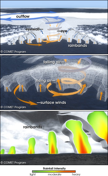
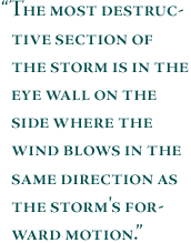
(Top) Surrounding the eye of the hurricane is a ring of thunderstorms, called the eyewall. Rainbands surround the eye of the storm in concentric circles. In the eyewall and in the rainbands, warm, moist air rises, while in the eye and around the rainbands, air from higher in the atmosphere sinks back toward the surface. The rising air cools, and water vapor in the air condenses into rain. Sinking air warms and dries, creating a calm, cloud-free area in the eye. (Middle) Low pressure at the ocean surface in the heart of the hurricane draws in surrounding air. These spiraling winds pick up speed as they approach the eye, pulling more heat and moisture from the ocean surface. (Bottom). The stronger the convection in the thunderstorms becomes, the more rain they produce. The more rain they produce, the more heat they release into the surrounding atmosphere, further fueling the storm. (Graphics Copyright © National Center for Atmospheric Research/The COMET Program.) Bordering the eye of a mature hurricane is the eye wall, a ring of tall thunderstorms that produce heavy rains and very strong winds. The most destructive section of the storm is in the eye wall on the side where the wind blows in the same direction as the storm’s forward motion. For example, in a hurricane that is moving due west, the most intense winds would be found on the northern side of the storm, since the hurricane’s winds are added to the storm’s forward motion. Surrounding the eye wall are curved bands of clouds that trail away in a spiral fashion, suitably called spiraling rain bands. The rain bands are capable of producing heavy bursts of rain and wind, perhaps one-half or two-thirds the strength of those associated with the eye wall. Storm SurgeAs a hurricane moves closer to land, coastal communities begin to feel the effects of heavy rain, strong winds, and tornadoes. However, its most destructive weapon is the accompanying storm surge, a rise in the ocean levels of up to 10 meters (about 33 feet). When a hurricane approaches the coast, an 80-to-160-kilometer-wide dome of ocean water sweeps over the coastline. Storm surges have demolished marinas, piers, boardwalks, houses, and other shoreline structures, while eroding beaches and washing out coastal roads and railroads. Strong onshore winds pushing the ocean surface ahead of the storm on the right side of the storm track (left side in the Southern Hemisphere) is the primary cause of the storm surge. This wall of water is greatest when the arrival of the storm coincides with the occurrence of an astronomical high tide. 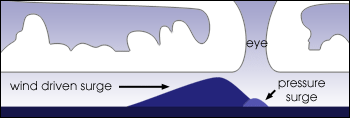
Strong winds are responsible for most of a hurricane’s storm surge, but the extremely low air pressure in the eye of the storm also plays a small role. The low pressure in the eye allows the surrounding atmosphere to compress the ocean surface into a small bulge. (Graphics by Robert Simmon, NASA GSFC.) The Saffir-Simpson ScaleIn the early 1970s, a classification system was designed to quantify the level of damage and flooding expected from a hurricane. This system was conceived by Herbert Saffir, a consulting engineer, and Robert Simpson, then the director of the National Hurricane Center. Using a mix of structural engineering and meteorology, they constructed the Saffir-Simpson Hurricane Intensity Scale, or simply, the Saffir-Simpson Scale. Consisting of 5 categories (1 being the weakest and 5 being the strongest), the scale corresponds to a hurricane’s central pressure, maximum sustained winds, and storm surge. Sustained wind speeds are the determining factor in the scale, as storm surge values are highly dependent on the slope of the continental shelf in the landfall region. Categories 3, 4, and 5 are considered major (intense) hurricanes, capable of inflicting great damage and loss of life. 
Category 1: Winds 119-153 km/hr (74-95 mph). Storm surge generally 4-5 feet above normal. No real damage to building structures. Damage primarily to unanchored mobile homes, shrubbery, and trees. Some damage to poorly constructed signs. Also, some coastal road flooding and minor pier damage. Winds from Hurricane Katrina damaged this sign in Dequincy, Louisiana. (Image Copyright © sidehike/Flickr.) 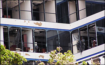
Category 2: Winds 154-177 km/hr (96-110 mph). Storm surge generally 6-8 feet above normal. Some roofing material, door, and window damage of buildings. Considerable damage to shrubbery and trees, with some trees blown down. Considerable damage to mobile homes, poorly constructed signs, and piers. Coastal and low-lying escape routes flood 2-4 hours before arrival of the hurricane center. Small craft in unprotected anchorages break moorings. Winds from Hurricane Wilma shattered windows in Fort Lauderdale, Florida, in 2005. (Image Copyright © Gary Musik/Flickr.) 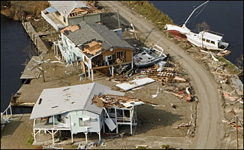
Category 3: Winds 178-209 km/hr (111-130 mph). Storm surge generally 9-12 ft above normal. Some structural damage to small residences and utility buildings, with a minor amount of curtain wall (non-load-bearing exterior wall) failures. Damage to shrubbery and trees, with foliage blown off trees, and large trees blown down. Mobile homes and poorly constructed signs are destroyed. Low-lying escape routes are cut by rising water 3-5 hours before arrival of the center of the hurricane. Flooding near the coast destroys smaller structures, with larger structures damaged by battering from floating debris. This photo shows extensive damage to private homes and boats in Christian Pass, Mississippi, in the aftermath of Hurricane Katrina. (Image Copyright © Andrea Booher/Federal Emergency Management Agency.) 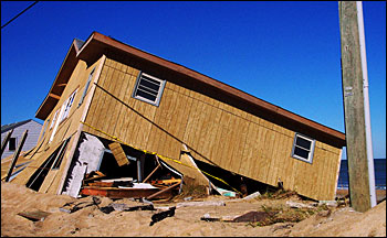
Category 4: Winds 210-249 km/hr (131-155 mph). Storm surge generally 13-18 feet above normal. More extensive curtain wall failures, with some complete roof structure failures on small residences. Shrubs, trees, and all signs are blown down. Complete destruction of mobile homes. Extensive damage to doors and windows. Low-lying escape routes may be cut by rising water 3-5 hours before arrival of the center of the hurricane. Major damage to lower floors of structures near the shore. Terrain lower than 10 feet above sea level may be flooded. Hurricane winds completely toppled this house in North Carolina. (Image Copyright © brighterworlds’ photos/Flickr.) 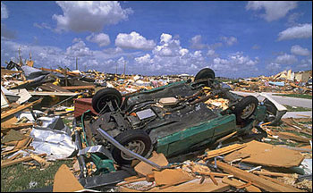
Category 5: Winds greater than 249 km/hr (155 mph). Storm surge generally greater than 18 feet above normal. Complete roof failure on many residences and industrial buildings. Some complete building failures, with small utility buildings blown over or away. All shrubs, trees, and signs blown down. Complete destruction of mobile homes. Severe and extensive window and door damage. Low-lying escape routes are cut by rising water 3-5 hours before arrival of the center of the hurricane. Major damage to lower floors of all structures located less than 15 feet above sea level and within 500 yards of the shoreline. This photo shows the aftermath of Hurricane Andrew in 1992. (Image Copyright © Greenpeace.) next: Hurricane Climatology
|
| ||