Deltas |
|||
Humans are transforming coastlines around the world. Some of the ongoing coastal modifications include building structures that regulate water and sediments (dams, seawalls, and jetties), ground water extraction leading to subsidence, and sea level rise induced by global warming. The increasing populations and development in coastal zones drive many of these changes. One example of a dynamic coastal zone selected for the Crew Earth Observations project is the Chinese coastline along the Gulf of Bohai. Here a combination of human and natural changes can be observed. The delta of the Yellow River is the fastest changing coast on the Earth’s surface. The lower river channel silts up rapidly, resulting in frequent river course changes. The river has been engineered for millennia, but recent water demands and water diversions (amplified by several years of drought in the 1990s) have resulted in little or no water reaching the coast. |
|||
|
|||
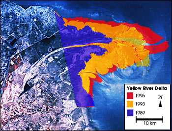
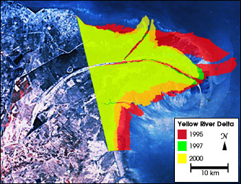
Between 1989 and 2000, astronauts on the Space Shuttle documented
dramatic changes in the tip of the Yellow River delta. Over this time,
several hundred square kilometers have accreted to and been eroded from
the coast. The delta grew nearly 400 square km between 1989 and 1995,
and then began eroding back. In 1997 a new channel was cut near the tip
of the delta, providing the water and sediment a shorter route to the
sea. Between 1995 and 1997, the delta area eroded back about 250 square
km. From 1997 to February 2000, the delta tip again grew nearly 100
square km. |
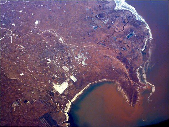
This image of the Yellow River delta was taken from the Space Shuttle in February 2000 using an electronic still camera as part of the EarthKAM Project Image # STS099.ESC.04093647 | ||
|
From 1989 to 1995 the Yellow River delta accreted (grew in area). Each of these outlines of the above-surface delta was measured from an astronaut photograph mapped to the common base. | ||
Remote sensing image analysis is an efficient strategy for examining regional changes that occur over large areas, and provides context for smaller-scale changes. The photographs collected by astronauts can be assembled in a time series of images that demonstrate both the scale and specific locations of coastal change. Change can be quantified when the images are referenced to standard maps. Such analyses can identify both natural and human-induced changes, lending some understanding of the processes involved in the coastline evolution. Other Asian deltas that will be a focus of Crew Earth Observations are those of the Yangtze, Irrawaddy, Mekong, and Ganges Rivers. |
From 1995 to 2000 the Yellow River delta eroded (shrank in area). Each of these outlines of the above-surface delta was measured from an astronaut photograph mapped to the common base. | ||