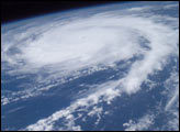
This photo of Hurricane Frances was taken by Astronaut Mike Fincke aboard the International Space Station as he flew 230 statute miles above the storm at about 9 a.m. CDT Friday, Aug. 27, 2004.
Published Aug 30, 2004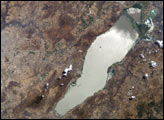
Astronauts aboard the Space Shuttle and Space Station have tracked regional environmental changes spanning decades. Lake Chapala, Mexico’s largest lake, serves as one example of an area experiencing significant changes that have been well documented from space. Over the past twenty years, the lake’s water levels have decreased in conjunction with increasing development from the fast-growing city of Guadalajara.
Published Aug 30, 2004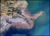
The Yellow River Delta coastline along the Gulf of Bohai has always experienced dramatic changes, and those changes continue today. This mosaic of images taken by astronauts aboard the International Space Station shows several things. First, the image shows today’s configuration of the delta of China’s Yellow River, which is one of the most dynamic coastlines on Earth. Second, the scene allows mapping of land use along the coastal plain, including the boundaries of the Shengli Oil Field, China’s second largest oil field. But perhaps the most interesting aspect of this image is the large patch of green water off the northern coast of the delta—a presumed plankton bloom.
Published Aug 23, 2004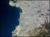
Athens, Greece, enjoys both historical and current significance on the world stage. The ancient city of Athens, considered to be the birthplace of many Western traditions in philosophy, the arts, and the scientific method, is located in the Central Plains region of Attica in eastern Greece. This astronaut photograph captures the western extent of the modern urban area.
Published Aug 16, 2004
The Dominican Republic occupies the eastern two-thirds of the island of Hispaniola in the Caribbean Sea. The island has a variety of ecosystems ranging from arid plains to tropical rain forests created by three roughly parallel east-west mountain ranges. The northernmost of these ranges, the Cordillera Septentrional, is visible in this astronaut photograph as the dark green region north of the river. Clearcut regions within the Cordillera Septentrional are visible as irregular light green regions interspersed with dark green forested areas.
Published Aug 9, 2004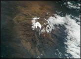
Most scientists agree that the glaciers of Mt. Kilimanjaro will be gone by the year 2020, but there is less agreement as to why they are now receding.
Published Aug 2, 2004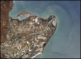
The Ebro River Delta, located along the eastern coast of Spain, is one of the largest wetland areas in the western Mediterranean region.
Published Jul 26, 2004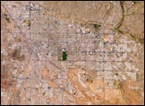
Tucson lies between the forested Catalina Mountains and the Tucson Mountains (dark reddish brown at the left image margin).The typical western North American cityscape is a pattern of regular north-south aligned rectangles outlined by major streets set one mile apart.
Published Jul 19, 2004
Located on the highly populated Hawaiian island of Oahu just west of Honolulu, Pearl Harbor is the historic center of events on “the day that will live in infamy”—December 7, 1941—when the Japanese fleet launched a surprise air attack on Pearl Harbor and other strategic military targets on Oahu. The ISS-6 Space Station crew obtained this high-resolution image of Pearl Harbor in March 2003, enabling detailed observations of the harbor and its multiple uses.
Published Jul 12, 2004
The roofs of Barcelona’s buildings appear as a widespread pink swath on the Mediterranean coastal plain, between forested hills (dark green, top) and the sea. The Llobregat River enters the view top center, cuts through a canyon in the hills and historically constructed a broad, convex delta south of the forested hills. Channelization of the Llobregat River to control flooding has encouraged development of the delta for a variety of urban and agricultural land uses. Barcelona’s airport is located in the central portion of the delta, while the western portion is used for intensive agriculture (light green areas).
Published Jul 5, 2004
The Colorado River is the largest watershed in the southwestern US, emptying into the Salton Trough before reaching the Sea of Cortez. Over the past 2-3 million years, river sediments built a delta that extends from the US-Mexico border for a distance of 87 miles (140 kilometers). However, today the Colorado River delta is undergoing significant erosion and diminishing in size due to the lack of sediment replenishment from upstream sources.
Published Jun 28, 2004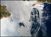
Surf’s up! This image is a mosaic of two photographs taken by astronauts aboard the International Space Station viewing large internal waves in the Strait of Gibraltar. These subsurface internal waves occur at depths of about 100 m, but appear in the sunglint as giant swells flowing eastward into the Mediterranean Sea. The narrow Strait of Gibraltar is the gatekeeper for water exchange between the Atlantic Ocean and Mediterranean Sea. A top layer of warm, relatively fresh water from the Atlantic Ocean flows eastward into the Mediterranean Sea. In return, a lower, colder, saltier layer of water flows westward into the North Atlantic ocean. A density boundary separates the layers at about 100 m depth.
Published Jun 21, 2004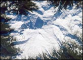
The Cascade Range is an arc of volcanoes that extends from southwestern British Columbia to northern California. One of the six major composite volcanoes (formed by alternating layers of extruded lava and compacted ash) is Mount Baker in northern Washington.
Published Jun 14, 2004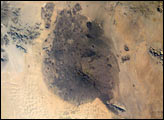
The Pinacates region of Mexico’s Sonoran Desert is one of the most unique and striking landscapes in North America. Located just a few miles south of the Mexico-Arizona border, this volcanic field originated with the rifting of the Gulf of California millions of years ago, but the features seen today (volcanic peaks, lava flows, cinder cones and collapsed craters) formed in the late Pleistocene period (2 million to 11,000 years ago). The volcanic range is surrounded by one of North America’s largest dune fields, Gran Desierto. Early in May 2004, the new Space Station crew (ISS-9) obtained high-resolution images of the Pinacates, allowing for detailed observations of the surface features. One example is a large volcanic crater (see box, and detail below) called Crater Elegante which is one of the most prominent and interesting features of the Pinacates.
Published Jun 8, 2004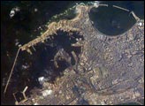
Founded by Alexander the Great in 331 BC on the Mediterranean coast of Egypt, Alexandria became a center of trade and learning in the ancient world. he Eastern Harbor was the main port in the Middle Ages. This detailed image taken by Space Station crew members using an 800-mm lens provides a view of the modern port facilities in the Western Harbor, where wharves and many moored ships can be detected.
Published May 31, 2004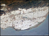
The sunny south of Spain offers more to the national economy than simply tourism. Over the past 50 years, the small coastal plain (campo), some 30 kilometers southwest of the city of Almería, has been intensively developed for agriculture. An estimated 20,000 hecatres of extra-early market produce is grown in greenhouses in the Campo de Dalías.
Published May 24, 2004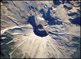
On May 18, 1980, Mount Saint Helens volcano erupted. Because the eruption occurred in an easily accessible region of the U.S., Mount St. Helens has provided unprecedented opportunities for U.S. researchers to collect scientific observations of the geology of an active volcano and document the regional ecological impact and recovery from an eruption.
Published May 17, 2004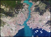
This metropolis of 15 million people occupies both sides of the entrance to the narrow, 20-mile long Bosporus Strait connecting the Mediterranean and Sea of Marmara (south) to the Black Sea (north). From its founding as Byzantium by the Greeks in 600 B.C., this strategically located city has been a focus of maritime trade and commerce as well as an outpost and threshold for cultural exchange and conflict between Europe and Asia. This digital camera image was taken by the crew of the International Space Station on April 16, 2004. When this image was taken, strong currents carried turbid coastal waters from the Black Sea through the Strait and into the Sea of Marmara.
Published May 10, 2004
With almost 23 million residents, Mumbai, India, is the second largest city in the world. Rapid population growth in Mumbai is evident in this image from the International Space Station that shows several regions of the city with active land reclamation activities on its coasts, bays and hinterlands.
Published May 3, 2004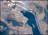
On April 26, 1986, the world’s worst nuclear power accident occurred at the Chernobyl Nuclear Power Plant near the Ukrainian-Belarus border. Toxic radionuclides like Cs137 and Sr90 contaminated an area of 155,000 square kilometers in what is today Belarus, Ukraine and Russia. Hundreds of thousands of people were killed, sickened from radiation-induced illnesses, or resettled to uncontaminated land. This image, taken from the Russian Mir spacecraft, shows Chernobyl and the surrounding countryside.
Published Apr 26, 2004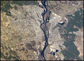
Kyiv is rich in the history of western civilization. It was a trade center on the Baltic-Black Sea route in the 11th and 12th centuries, and one of the major cities in the Christian world, until Mongol invaders destroyed the city in 1240. Some of the 11th-century cathedrals, which contain famous artifacts, remain standing and have been restored.
Published Apr 19, 2004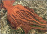
The Betsiboka Estuary on the northwest coast of Madagascar is the mouth of Madagascar’s largest river and one of the world’s fast-changing coastlines. Nearly a century of extensive logging of Madagascar’s rainforests and coastal mangroves has resulted in nearly complete clearing of the land and fantastic rates of erosion. After every heavy rain, the bright red soils are washed from the hillsides into the streams and rivers to the coast. Astronauts describe their view of Madagascar as “bleeding into the ocean.” One impact of the extensive 20th century erosion is the filling and clogging of coastal waterways with sediment—a process that is well illustrated in the Betsiboka estuary. In fact, ocean-going ships were once able to travel up the Betsiboka estuary, but must now berth at the coast.
Published Apr 12, 2004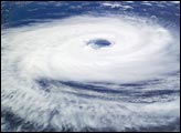
Until March 2004, only two tropical cyclones had ever been recorded in the South Atlantic Basin, and no hurricanes.
Published Apr 5, 2004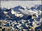
Astronauts on board the International Space Station (ISS) have a unique view of the world because of their position in a low orbit (200 nautical miles, 360 kilometers) relative to satellites and their ability to look at any angle out the windows of the spacecraft. ISS crewmembers recently took advantage of their vantage point to photograph a series of oblique views of the Himalayas looking south from over the Tibetan Plateau. At first glance, one might think that the image looks like a picture taken from an airplane, until you remember that the summits of Makalu (left, 8,462 meters, or 27,765 feet) and Everest (right, 8,850 meters, or 29,035 feet) are at the heights typically flown by commercial aircraft. The full mosaic covers over 130 kilometers (80 miles) of the Himalayan front, and could never be seen this way from an airplane.
Published Mar 29, 2004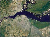
This image, taken from the International Space Station on June 6, 2003, shows two capital cities on opposite banks of the Congo River. The smaller city is Brazzaville on the north side of the river, and Kinshasa on the south side. The cities lie at the downstream end of an almost circular widening in the river known as Stanley Pool. The international boundary follows the south shore of the pool (roughly 30 kilometers in diameter).
Published Mar 22, 2004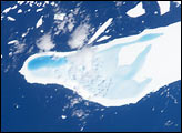
In January, 2004, astronauts on board the International Space Station took this detailed picture of melt water pooled on the surface of iceberg A-39D, a 2-kilometer wide, 11-kilometer long iceberg and drifting near South Georgia Island. The different intensities of blue are interpreted as different water depths. From the orientation of the iceberg, the deepest water (darkest blue) lies at the westernmost end of the iceberg. The water pools have formed from snowmelt—late January is the peak of summer in the Southern Hemisphere.
Published Mar 15, 2004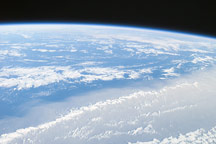
This image was taken from the International Space Station on March 8, 2004, from a position about 1400 kilometers off the coast of Mauritania (about 600 kilometers west of the Cape Verde Islands). Looking northwest, this image shows the dusty Saharan airmass in the lower third of the view, with clear air beyond a marked northeast-trending boundary. The dust, which originated in Central Africa, is blowing west southwest, parallel to the front—a common trajectory during northern winters.
Published Mar 12, 2004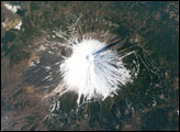
Fuji, Japan’s tallest volcano (3,776 m) and a national symbol, is located about 110 km (70 miles) west-southwest of Tokyo in central Honshu, Japan. It is a highly recognizable target from space. The summit crater is about 250 m deep, with a diameter of about 500 meters.
Published Mar 8, 2004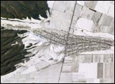
The striking land use pattern, seen through a high magnification lens and highlighted by winter snow and low Sun angles, produces a unique view of the village of Argudan near the north slopes of the Greater Caucasus Mountains. The image was taken with a handheld camera from the International Space Station in the early afternoon of December 20, 2003. This rural, agricultural community sits astride the main highway about 15 kilometers east-southeast of the city of Nalchik. Shadows from a line of trees planted as a windbreak near the highway give the road a ragged appearance. A small stream flowing northeastward exits heavily forested foothills through the village and fields of intensely cultivated croplands on the plains. Snow falls through the vegetation, making the woodlands appear extremely dark compared to the snow-covered fields. Astronauts also photographed nearby Nalchik, a tourist resort and industrial center. It is the major city of the Kabardino-Balkar Republic (population around 750,000), one of five small republics on the north slopes of the Caucasus Mountains, 200 kilometers west of Chechnya.
Published Mar 1, 2004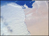
This striking photograph shows a massive sandstorm sweeping over the Persian Gulf state of Qatar as it races southward toward southeastern Saudi Arabia and the United Arab Emirates on February 15, 2004. A major upper-level, low-pressure system over southwestern Asia led to a series of storms sweeping through the area.
Published Feb 26, 2004