By Clément Miège
Hi there! I am Clément Miège, a Ph.D. student at the University of Utah and I am going to take you along with us to our second expedition to the southeast region of Greenland, to investigate the physical properties of a firn aquifer. And what is a firn aquifer, you might be wondering? It’s a reservoir of perennial water (that is, water that doesn’t freeze in the winter) that is trapped within the compacted snow layer (or firn) of the Greenland ice sheet. If you didn’t follow last year’s edition of this expedition and/or you want to learn more about the firn aquifer, here are some readings I recommend:
We are now getting ready for another expedition to Greenland to further monitor the firn aquifer. This year, our four main tasks will be to maintain our equipment currently in place (which performs temperature measurements), collect additional measurements (with a radar), install a weather station, and try traditional ground-water techniques to date the water and calculate its permeability. I will explain in future blog posts why these measurements are important.
I will be part of a smaller team this year, since only three out of the five members of the first-year team are joining. Rick Forster and I will represent the University of Utah, while Ludovic Brucker comes from NASA Goddard Space Flight Center.

The Greenland Aquifer team in 2013.
Here is the photo of the team from last year, from left to right; Jay, Ludo, Rick, Lora and I. Lora and Jay won’t be coming to the field this year (we sure will miss them!) If you want to know a bit more about each team member (current and former), you can check this blog post from last year.
Even when we haven’t set a foot in the field yet, the expedition to Greenland started about two months ago with organizing the logistics. Logistics can sometimes be underestimated, but it takes a lot of effort prior to getting to the field to prepare and test the scientific equipment and other field supplies, such as camping gear, food, and power sources.
For this expedition, all of the science equipment (GPS, radars with different frequencies — 5MHz to 400MHz–, piezometers, ice-core drill) was gathered from different institutions in Utah to be packed here and shipped to Kulusuk. Most of the non-perishable food and camping gear was left for over-winter storage after last year’s expedition in a warehouse in Kulusuk, to save on shipping costs.
On March 3 this year, the Utah gear left for Greenland; we’re talking about 800 lbs. of gear that left Salt Lake City on a truck headed to the JFK airport in New York, where it was flown to Reykjavik (Iceland) and then to Kulusuk (Greenland). We got a phone call early this week from our shipping company to confirm that all our equipment made it to Greenland — great news!

Gear packed at the office (left) and ready to leave the shipping facility at the University of Utah (right). We will see this gear again in Greenland!
These last days have been really busy, gathering the last items for our science research, and also personal equipment. Yesterday, I was working at Blue System Integration in Vancouver, BC with a colleague, Laurent Mingo, who is developing IceRadar, an ice-penetrating radar system for the scientific community (see this website for additional info). Laurent has been working on an experimental beta version of the current radar that will allow us to penetrate through the firn aquifer to try to image the bottom of the aquifer gradually transitioning from water-saturated firn to ice.
Even if most of the scientific equipment is already shipped, there are always some last-minute important items that we end up adding into our suitcases (like the low-frequency radar). As a brief anecdote, last year, Rick traveled with a pelican case as a checked bag – inside, there was a bunch of wires hooked up to a datalogger. We were aware that it looked kind of suspicious, so it was a bit scary to go through customs with it! Me, I traveled with a 60-meter long thermistor string weighing over 50 lbs. in my checked bag, because the fabrication and calibration took longer than expected and we weren’t able to ship it ahead of time with the rest of the equipment. This year, luckily, most of the heavy equipment was ready on time and we are carrying only a couple random items in our checked bags.
We are starting our journey this week, leaving the U.S. on Thursday evening for Reykjavik, the capital of Iceland. After a day in Reykjavik, we will leave mid-Saturday on a 2-hour short flight that will take us to Kulusuk, Greenland. We are hoping for good weather; last year, Ludo and I “boomeranged” on our first try due to poor visibility at the Kulusuk runway.
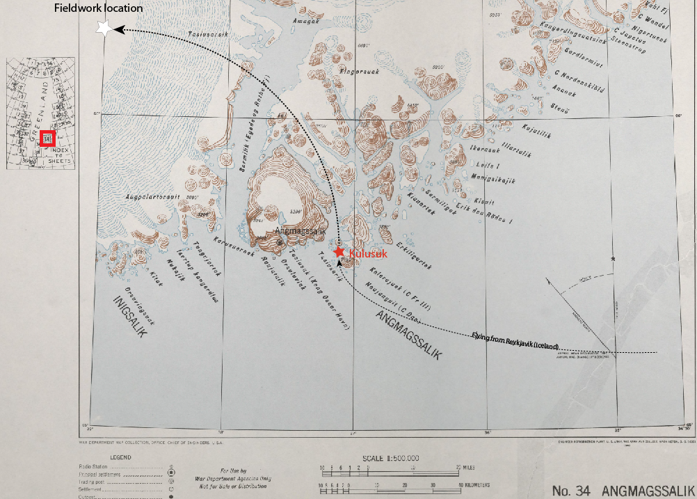
In this old map from the US army (from 1941) you can see the location of the small city of Kulusuk in Southeast Greenland (red star), just below the Arctic Circle (~66.5°N). Our field camp on the ice sheet is represented by a white star. The map can be found at the Polar Geospatial Center.
Kulusuk is our first stop in Greenland. We will be staying at this small village for a few days in order to re-pack our field gear, test that everything is working well (stoves, generators, tents, science equipment, etc.) before going to the field. If we are lucky, we might see one of the polar bears that sometimes come close to town in this time of year.

Colorful houses make up the town of Kulusuk in Southeast Greenland. The shores of the fjord are covered by sea ice in the winter.
After a couple of days, we will be heading to our fieldwork location on the ice sheet. A helicopter from Air Greenland will drop us and our cargo at our study site; it will be an about 45-minute commute.
That is it for this introduction; our next blog post will be from Greenland!
All the best,
Clément
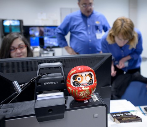
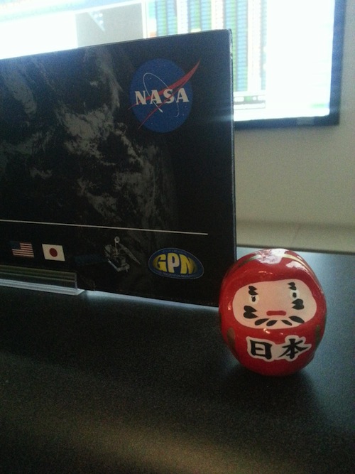
Every mission has its little offerings to fate to back up the hard work and attention to detail that goes into prepping for launch. While in Japan, the GPM team adopted the Japanese custom of coloring in one eye of a Daruma doll.
I first encountered it when visiting the support control room for the launch dress rehearsal last weekend in the Spacecraft Test and Assembly building at Tanegashima Space Center. Sitting on top of one of the computers was a round, squat, stylized doll. Lisa Bartusek, one of the systems engineers on console for the rehearsal, explained that in Japan, the Daruma doll is often given as a gift of encouragement for working toward a goal. When the goal is set, one eye is colored in. When the goal is achieved, the second eye is colored in.
A Daruma doll is seen amongst the NASA GPM Mission launch team in the Spacecraft Test and Assembly Building 2 (STA2) during the all-day launch simulation for the Global Precipitation Measurement (GPM) Core Observatory, Saturday, Feb. 22, 2014, Tanegashima Space Center (TNSC), Tanegashima Island, Japan. Credit: NASA/Bill Ingalls
My reaction to seeing it was that it would definitely motivate me to finish a goal: a doll with only one eye filled in, looking lopsided, would drive me nuts.
The GPM team has several Daruma dolls. The one for the team on console in Tanegashima was for a safe and successful launch. Back at Goddard Space Flight Center in Greenbelt, Md. a second and third Daruma doll sat in the Launch Support Room (LSR) and the Mission Operations Center where the GPM team is runs the mission now that the GPM Core Observatory is in space. For the Goddard team, their goal was to have the GPM Core Observatory separate from the rocket, get communications running, deploy solar arrays and point toward the sun to collect power. Those were the big moments for the team in the hot seat.
Caitlin Bacha on the GPM propulsion team was on console in the LSR at Goddard and wrote to me a few hours after launch. “Wahoo! Success!! I also think it’s funny how many videos have all the cheering after the rocket goes up. In here it was silent. The cheers came 10 min after with acquisition of signal. And again with the solar arrays deployed. Since then it’s been a flurry of activity in the LSR!”
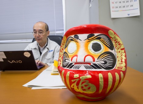
JAXA has a daruma doll, too. One is seen on the desk of Masahiro Kojima, GPM Dual-frequency Precipitation Radar project manager, Japan Aerospace Exploration Agency (JAXA), at the Tanegashima Space Cener’s Range Control Center (RCC), Wednesday, Feb. 26, 2014, Tanegashima, Japan.
After GPM’s successful launch at 3:37 a.m. (JST) on Friday, Feb 28, the team started coloring in the eyes.
The colored in eye of the Daruma doll in the Tanegashima launch support room, Feb 28 (post-launch JST). Credit: Cody Buell
The Daruma doll in the Mission Operations Center at Goddard Space Flight Center in Maryland, the eye colored in post-solar array deploy, Feb 27 (post-launch U.S. EST). Credit: Eish Patel
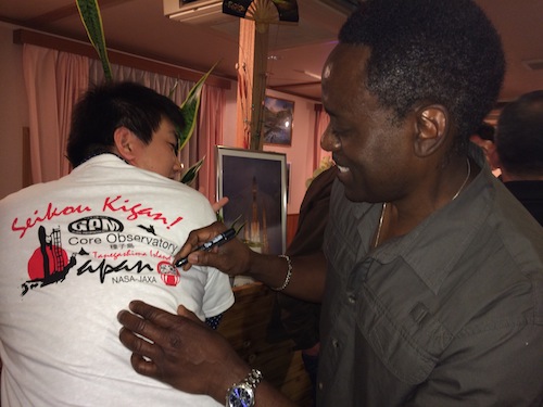
Larry Morgan, quality assurance, fills in the eye of the Daruma doll on the back of a MHI engineer’s t-shirt, Feb 28, Tanegashima, Japan. Credit: Lynette Marbley
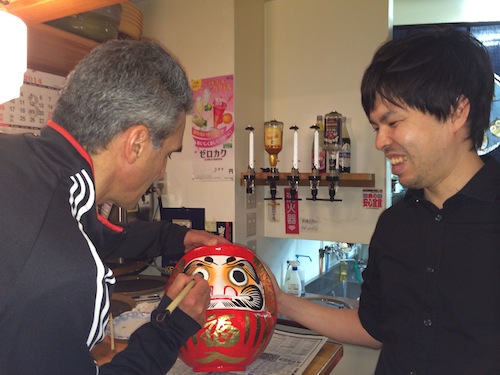
Art Azarbarzin, GPM project manager, fills in the second eye of the JAXA Daruma doll at the party after launch with JAXA engineer Hyakusoku Yasutoshi, Feb 28. Credit: Lynette Marbley
The only one still uncolored is the one in launch support room at Goddard. When I asked for photos after launch, Lisa wrote me that the team at Goddard has extended their goal to include powering up the instruments. The GPM Microwave Imager was turned on Mar. 1. The Dual-frequency Precipitation Radar had its controller turned on as well, and full power-up is scheduled for later in the week.
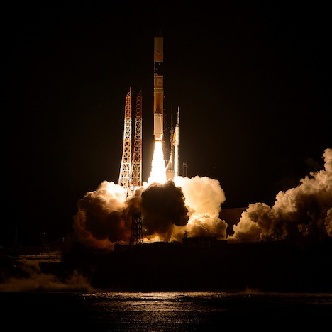
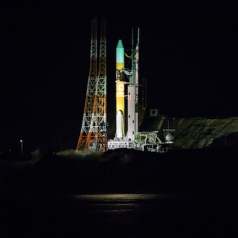
A Japanese H-IIA rocket, with the NASA-Japan Aerospace Exploration Agency (JAXA) Global Precipitation Measurement (GPM) Core Observatory onboard, is seen launching from the Tanegashima Space Center, Friday, Feb. 28, 2014, Tanegashima, Japan. The GPM spacecraft will collect information that unifies data from an international network of existing and future satellites to map global rainfall and snowfall every three hours. Photo Credit: (NASA/Bill Ingalls)
Launches are something special and this one was was spectacular. We were 3 kilometers (1.9 miles) from the launch pad, the absolute minimum safe distance at the Takesaki Observation Stand. The roof doubles as a tiered deck, and lined up at every available railing was a tripod and a camera.
Since we had arrived a couple days in advance, producer Michael Starobin and photographer Bill Ingalls staked out a prime spot early. Down in front was a giant digital countdown clock, and as the hours and then the minutes ticked by, periodic announcements in Japanese and then English came over the loud speaker.
Global Precipitation Measurement, a mission to study rainfall and snowfall around the world, is my third launch. Since I’d been manning the @NASA_Rain account since 11p.m., my head wasn’t in launch mode right away, even when I joined Michael and Bill out at twenty minutes to go. Bill asked me to push a button for one of his cameras, and I was pre-occupied with that for a bit. There’s only so much staring at the rocket pad I could do before the lure of social media pulled me back in to my phone.
But then the last poll came across the speakers at 8 minutes to launch, and then the relentless countdown by a female voice Japanese began. Then it got real.
Across the distance the rocket was lit up on the pad. The countdown continued, a second voice announcing on top of the first — Observatory on internal power — 30 seconds — my heart started pounding as the adrenaline hit — 15 … 10 … 5 — my eyes were bouncing between the clock and the rocket— 4, 3, 2, 1. Zero.
[youtube 6vJCerH3AfE]
The H-IIA lit up the black of night, bright and beautiful. It was so bright I couldn’t see the rocket at all at first, but then it was rising up and up and up — the rumble reached us some twenty seconds later; you could feel it in your chest — the main engine blazing until it was right overhead. A minute or so in, we could just make out the solid rocket boosters falling away. The rocket kept going, a bright light against the field of stars, going and going for several more minutes until it was just another pinprick in the sky.
Three critical things happen after launch. The first is fairing jettison, when, about four minutes after liftoff, the white nose cone that protects the spacecraft through the atmosphere releases and falls away. Meanwhile, the spacecraft is still attached to the rocket. The second is spacecraft separation, which occurred at a little over 15 minutes. At that point, the rocket was too high to see, so we returned inside to watch it on the telemetry and the camera attached to the rocket.
A whole line of Mitsubishi and JAXA public affairs people were lined up waiting, the press waiting for their reaction. As the only NASA person in the room not holding a camera, the JAXA folks asked me to join them, and we all watched the monitor, waiting for the next minutes to pass. The excitement was high in the room — launch so far had gone flawlessly. Then the black and white rocket cam showed the spacecraft surrounded by black; it had successfully separated and we all grinned and clapped.
A minute later I was back at my computer, checking the @NASA_Rain twitter account, #GPM, and the GPM website for updates, waiting for the next milestone. Solar array deploy complete and collecting power. The GPM Core Observatory was safely in space.
Photos of launch are at NASA HQ Flickr GPM set.
Mission updates are on the front page of www.nasa.gov/gpm
When you’re a three person team out in the field, there’s not always enough time to get it all done.
A Japanese H-IIA rocket with the NASA-Japan Aerospace Exploration Agency (JAXA), Global Precipitation Measurement (GPM) Core Observatory onboard, is seen on launch pad 1 of the Tanegashima Space Center, Friday, Feb. 28, 2014, Tanegashima, Japan. Once launched, the GPM spacecraft will collect information that unifies data from an international network of existing and future satellites to map global rainfall and snowfall every three hours. Photo Credit: (NASA/Bill Ingalls)
We are Launch minus 1 hour. The weather is clear, the rocket is fueled, all systems are GO.
In the press room, reporters are grabbing their hard hats and the cameras and heading up to the roof. I’ll be joining them shortly.
Live launch coverage has started on NASA TV and online at www.nasa.gov/nasatv
Latest mission milestones will be flying thick and fast on www.nasa.gov/gpm
And below is all the coverage Michael, NASA photographer Bill Ingalls, and I have done over the last week.
Go GPM!
Photos!
NASA HQ Flickr
http://www.flickr.com/photos/nasahqphoto/sets/72157641344480584/
Features, Video, and Featured photos
GPM’s H-IIA Rocket Rolls Out to the Launch Pad
The H-IIA rocket with the Global Precipitation Measurement Core Observatory aboard rolled out to Launch Pad 1 at 1:04 p.m. on Feb. 27 (Japan time) at Tanegashima Space Center, Japan. The rocket is scheduled to lift off during a launch window that opens at 3:37 a.m. (JST) on Feb. 28. (1:37 p.m. Feb. 27 EST).
http://www.nasa.gov/content/goddard/gpms-h-iia-rocket-rolls-out-to-the-launch-pad/
Home Stretch for GPM Team in Japan
It’s the home stretch for the GPM engineering team from NASA’s Goddard Space Flight Center, that has been on site at Tanegashima Space Center in Japan.
http://www.nasa.gov/content/goddard/home-stretch-for-gpm-engineering-team-in-japan
GPM: Waiting for Launch
The Global Precipitation Measurement mission’s Core Observatory is poised for launch from the Japan Aerospace Exploration Agency’s Tanegashima Space Center, scheduled for the afternoon of Feb. 27, 2014 (EST).
http://youtu.be/nnjL0AwFu9g
Landsat 8 Eyes Japan, GPM Launch Site
This Landsat 8 satellite image of some southern Japanese islands includes Tanegashima (far right), from where the GPM mission’s Core Observatory is
http://www.nasa.gov/content/goddard/landsat-eyes-japan-gpm-launch-site/
GPM’s Last Stop Before Orbit
Art Azarbarzin, NASA’s Global Precipitation Measurement mission project manager, and Mashahiro Kojima, the Japan Aerospace Exploration Agency’s GPM/DPR project manager, reflect on the long journey the GPM Core Observatory spacecraft has taken to reach its last stop before orbit, the Tanegashima Space Center, Japan.
http://youtu.be/9AnLxge5ONY
GPM: Three Shrine Pilgrimage
Japan Aerospace Exploration Agency (JAXA) team members bow at the Ebisu Shrine, the first shrine in a traditional San-ja Mairi, or Three Shrine Pilgrimage, where the team prays on Tuesday, Feb. 25, 2014 for a successful launch, Tanegashima Island, Japan.
http://www.nasa.gov/content/goddard/gpm-three-shrine-pilgrimage/
Live from Japan: Chatting About NASA’s Next Earth Science Mission
Three days before launch of the Global Precipitation Measurement (GPM) Core Observatory from Tanegashima Space Center in Japan, NASA staff supporting the mission set up shop in the lobby of the Sun Pearl Hotel in nearby Minamitane for a live Twitter Q-and-A to answer questions about the mission and what it will do in orbit.
http://www.nasa.gov/content/goddard/live-from-japan-chatting-about-nasas-next-earth-science-mission
NASA GPM Core Observatory’s Rehearsal Weekend at Tanegashima (also made the front page of www.nasa.gov)
On a small island in southern Japan, a satellite that will measure rain and snowfall over most of the globe prepares for launch.
http://www.nasa.gov/content/goddard/nasa-gpm-core-observatorys-rehearsal-weekend-at-tanegashima/
GPM: Greetings from Minamitame!
This video introduces Minamitame Town, near the Japan Aerospace Exploration Agency’s Tanegashima Space Center, from where the Global Precipitation Measurement mission’s Core Observatory is scheduled to launch on the afternoon of Feb. 27, 2014 (EST).
http://youtu.be/b__X7_u6uDk
GPM: Welcome to Minamitane Town
A sign with a model of the Japanese H-IIB rocket welcomes visitors to Minamitane Town on Saturday, Feb. 22, 2014. Minamitane Town is one of only a few small towns located outside of the Japan Aerospace Exploration Agency’s Tanegashima Space Center, where the launch of an H-IIA rocket carrying the Global Precipitation Measurement Core Observatory will take place in the next week.
http://www.nasa.gov/content/goddard/gpm-welcome-to-minamitane-town/
GPM: Tanegashima Space Center
A full-size model of an H-II rocket is seen at the Japan Aerospace Exploration Agency’s Tanegashima Space Center visitors center a week ahead of the planned launch of an H-IIA rocket carrying the Global Precipitation Measurement Core Observatory, Friday, Feb. 21, 2014, Tanegashima Island, Japan.
http://www.nasa.gov/content/goddard/gpm-tanegashima-space-center/
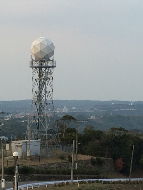
A dome protected weather radar just south of Minamitane is part of a weather station for Tanegashima Space Center. Feb 23. Tanegashima, Japan. Credit: NASA/Ellen Gray
I hear it was snowing in Maryland last night/today. In my inbox this evening (East Coast morning), I got the boilerplate message that while Goddard Space Flight Center is open on Feb. 26, non-critical and non-emergency personal could telework or take leave to avoid the snowy roads. The GPM team members scheduled to be on console for Thursday’s launch of the Global Precipitation Measurement Core Observatory are definitely critical.
As I write this in Tanegashima, I’ve been listening to a rainstorm blow across the island. Earlier, the wind was so loud outside of the Spacecraft Test and Assembly building where the GPM project offices are that Michael Starobin and I were worried about driving back to the hotel. The roads are narrow and twisty, which is bad enough after dark when we have drive on the opposite side of the road than we do in the States. Fortunately, when we walked outside the heavy rain we feared hadn’t hit yet, but the wind was wind you lean into.
Weather is one of the deciding factors for when a launch actually happens. It’s also the most fickle. Today, the first launch weather report was issued at Tanegashima Space Center at the Launch Readiness Review, the last major review panel of NASA and JAXA officials who gave GPM a go for launch on Feb. 28 (Feb. 27 in the U.S.) with an updated launch window beginning at 3:37 a.m. (1:37 p.m. EST).
Despite the rain here, the weather forecast for liftoff looks good. From the official update: “Weather at T-0 is forecast to be some scattered clouds with light winds, neither of which are expected to affect launch. Winds at launch are forecast to be 13 mph (violation is 47 mph).”
In about 28 hours, we’ll be watching a relatively clear night sky light up.
For those following along at home, live coverage of launch will begin at 12 noon EST on NASA TV. You can watch streaming online at: http://www.nasa.gov/nasatv
alert message
