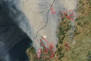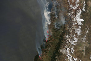

Wildfires have consumed roughly 273,000 hectares (1,060 square miles) and killed at least 10 people in Chile, according to news reports. Some outlets are calling it the worst fire outbreak in the nation’s history.
In the late morning on January 25, 2017, the Moderate Resolution Imaging Spectroradiometer (MODIS) on NASA’s Terra satellite acquired a natural-color image of fires near the coast of Chile. The MODIS instrument on NASA’s Aqua satellite acquired the second image in the early afternoon on the same day. Red outlines indicate areas with heat signatures indicative of active burning.
NASA images by Jeff Schmaltz, LANCE/EOSDIS Rapid Response. Caption by Mike Carlowicz.
The nation is enduring some of the most widespread fires on record.
Doxens of fires blazed in central Chile in January 2017.

