The Earth Observatory has published its last Image of the Day on this website. Please join us on our new home at science.nasa.gov/earth/earth-observatory.
In most American states, the Turtle Mountains—which rise 600 to 800 feet (180 to 240 meters) above the surrounding plain—would be called hills. But in North Dakota, one of the flattest states, people have a habit of calling even relatively modest rises mountains. (In the past, the U.S. Board of Geographic Names argued that mountains should have at least 1,000 feet (300 meters) of local relief to earn the designation, but the group abandoned the argument for linguistic consistency in the 1970s.)
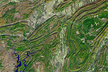
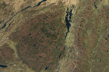
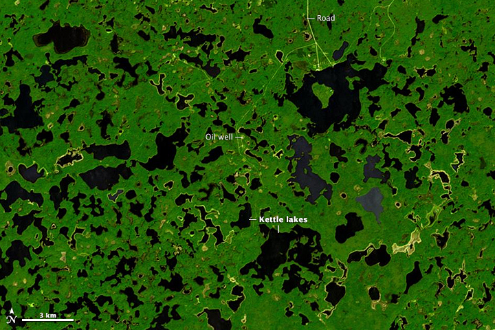
Whether hills or mountains, the hummocky highlands that straddle the border between North Dakota and southern Manitoba have enough elevation that they receive significantly more precipitation than the surrounding plains. As shown by this image from the Advanced Spaceborne Thermal Emission and Reflection Radiometer (ASTER) on NASA’s Terra satellite, enough moisture collects on the hills to support forests. The surrounding lowlands are a patchwork of grasslands and farms. In the lower image, a detailed view of a largely undeveloped part of Turtle Mountain Provincial Park, hundreds of ponds and lakes pockmark the landscape. A few roads and oil wells also appear.
The lakes make for picturesque canoeing and camping destinations for travelers. But in the eyes of geologists, they are clues pointing to a cooler period when the hills were blanketed by ice. About 25,000 years ago, ice sheets flowed southward over the Turtle Mountains. As the climate warmed between 15,000 and 13,000 years ago, that ice began to thin until glaciers on the hills stagnated and stopped flowing. Over time, a layer of sediment and other debris built up on top of these stalled glaciers and insulated the ice. Geologists think this blanket of sediment postponed the buried ice around the Turtle Mountains from melting for about 3,000 years. (Glaciers without debris were gone by about 12,000 years ago, while the Turtle Mountains still had stagnant glaciers up until 9,000 years ago).
The combination of stalled glaciers and the thick layer of uneven sediment helped create the pockmarked landscape—sometimes called “dead-ice moraine”—that defines the Turtle Mountains. For instance, many of the lakes shown in the satellite image were formed when blocks of buried ice melted, leaving space underground for the overlying sediment to slump down. This left depressions in the surface that geologists call kettles. Over time, many kettles filled with water, leaving the familiar “kettle lakes” or “prairie potholes” that are so common in the Turtle Mountains today.
For some helpful diagrams that show how the melting, buried glaciers sculpted the hills and other features found in the Turtle Mountains, see this primer from the North Dakota Geological Survey.
Image courtesy NASA/GSFC/METI/ERSDAC/JAROS, and U.S./Japan ASTER Science Team. Caption by Adam Voiland.