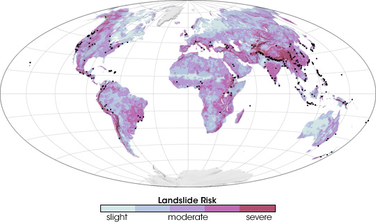


Heavy rain and steep mountains make for a potentially disastrous combination. On February 17, 2006, for example, torrential rain pounded mountainous Leyte Island in the Philippines and triggered a massive landslide that killed more than 1,100 people without warning. Remote regions in developing countries are particularly at risk from landslides because they lack of any sort of early-warning system. Robert Adler and Yang Hong, scientists at NASA Goddard Space Flight Center and the NASA Goddard Earth Science and Technology Center, are striving to reduce the loss of life from landslides by developing a global, satellite-based early-warning system. The scientists first identified landslide-prone regions, as shown in this image.
The most landslide-prone regions are typically mountainous, have coarse soil, or lack vegetation to anchor the soil in place. A deforested mountainside, for example, would pose a high risk for landslides. To create this landslide risk map Adler and Hong mapped all of the regions that featured some combination of coarse soil, landcover that was inadequate to stabilize the surface, and/or steep mountains. The regions that have the highest risk of landslides are salmon pink. Areas of moderate risk are lavender, and regions with a slight risk are pale blue. Areas where landslides occurred between 2003 and 2006 are marked with black dots on this map.
The risk map serves as the basis for Adler and Hong’s early-warning system. Using regional landslide risks, the pair determined a regional rainfall threshold beyond which landslides are likely. The threshold is relatively low in high risk areas, which need less rain to trigger a slide than low risk areas. The thresholds in place, Adler and Hong collect near-real-time rainfall data from the Multi-satellite Precipitation Analysis, which is based on measurements recorded by the Tropical Rainfall Measuring Mission (TRMM) satellite. When rainfall becomes intense enough to trigger a landslide, they mark the location on a map of potential landslide areas, which is freely available over the Internet. The map, they hope, will provide some form of warning in places that have no other warning system in place.
To read more about Adler and Hong’s work, see Satellite Monitors Rains that Trigger Landslides on the Earth Observatory.
NASA map by Robert Simmon, adapted from Hong, Y., Adler, R., and Huffman, G. (2006). Evaluation of the potential of NASA multi-satellite precipitation analysis in global landslide hazard assessment. Geophysical Research Letters, 33, L22402, doi:10.1029/2006GL028010.