|
Early History
Around 340 B.C., the Greek philosopher Aristotle wrote Meteorologica, a philosophical treatise that included theories about the formation of rain, clouds, hail, wind, thunder, lightning, and hurricanes. In addition, topics such as astronomy, geography, and chemistry were also addressed. Aristotle made some remarkably acute observations concerning the weather, along with some significant errors, and his four-volume text was considered by many to be the authority on weather theory for almost 2000 years. Although many of Aristotle’s claims were erroneous, it was not until about the 17th century that many of his ideas were overthrown. Throughout the centuries, attempts have been made to produce forecasts based on weather lore and personal observations. However, by the end of the Renaissance, it had become increasingly evident that the speculations of the natural philosophers were inadequate and that greater knowledge was necessary to further our understanding of the atmosphere. In order to do this, instruments were needed to measure the properties of the atmosphere, such as moisture, temperature, and pressure. The first known design in western civilization for a hygrometer, an instrument to measure the humidity of air, was described by Nicholas Cusa (c.1401-1464, German) in the mid-fifteenth century. Galileo Galilei (1564-1642, Italian) invented an early thermometer in 1592 or shortly thereafter; and Evangelista Torricelli (1608-1647, Italian) invented the barometer for measuring atmospheric pressure in 1643. While these meteorological instruments were being refined during the seventeenth through nineteenth centuries, other related observational, theoretical, and technological developments also contributed to our knowledge of the atmosphere; and individuals at scattered locations began to make and record atmospheric measurements. The invention of the telegraph and the emergence of telegraph networks in the mid-nineteenth century allowed the routine transmission of weather observations to and from observers and compilers. Using these data, crude weather maps were drawn and surface wind patterns and storm systems could be identified and studied. Weather-observing stations began appearing all across the globe, eventually spawning the birth of synoptic weather forecasting, based on the compilation and analysis of many observations taken simultaneously over a wide area, in the 1860s.
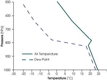
With the formation of regional and global meteorological observation networks in the nineteenth and twentieth centuries, more data were becoming available for observation-based weather forecasting. A great stride in monitoring weather at high altitudes was made in the 1920s with the invention of the radiosonde. Small lightweight boxes equipped with weather instruments and a radio transmitter, radiosondes are carried high into the atmosphere by a hydrogen or helium-filled balloon that ascends to an altitude of about 30 kilometers before bursting. During the ascent, these instruments transmit temperature, moisture, and pressure data (called soundings) back to a ground station. There, the data are processed and made available for constructing weather maps or insertion into computer models for weather prediction. Today, radiosondes are launched every 12 hours from hundreds of ground stations all over the world.
|
Weather Forecasting Through the Ages
| ||
|
next: Towards Numerical Prediction
|