| |
Modern Tools of the Trade
Modern technology, particularly computers and weather satellites, and
the availability of data provided by coordinated meteorological
observing networks, has resulted in enormous improvements in the
accuracy of weather forecasting. Satellites, in particular, have given
forecasters routine access to observations and data from remote areas of
the globe. On April 1, 1960, the polar-orbiting satellite TIROS 1 (the
first in the series of Television and Infrared Observation Satellites)
was launched. Although the spacecraft operated for only 78 days,
meteorologists worldwide were ecstatic over the pictures of the Earth
and its cloud cover that TIROS relayed back to the ground.
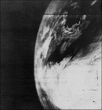
The first picture of Earth from a weather satellite,
taken by the TIROS-1 satellite on April 1, 1960. Although primitive in
comparison with the images we now receive from satellites, this first
picture was a major advance.
Over the past 40 years, satellite sensor technology has advanced
enormously. In addition to providing visual images, satellites can also
provide data that allow calculation of atmospheric temperature and
moisture profiles and other environmental variables. This is done using
a variety of instruments, among them atmospheric sounders, which measure
quantities at various levels in atmospheric columns. The data retrieved
from sounder measurements taken from a satellite can be made similar to
radiosonde observations, with the major advantage that the satellite
data are more complete spatially, filling in gaps between weather ground
stations, which often are hundreds or even thousands of kilometers
apart.
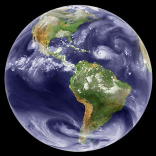
Full-disk GOES-8 water vapor image from September 5, 1995. (Courtesy of Marit Jentoft-Nilsen.)
|
|
Weather Forecasting Through the Ages
Introduction
Early History
Towards Numerical Prediction
Modern Tools of the Trade
The Aqua Spacecraft
Benefits to Society
References
|
