Extending Water Quality Measurements |
|||
Researchers at Michigan State University and the University of Wisconsin are now working to construct statewide water quality maps of their own. Lillesand, who is leading the RESAC effort in Wisconsin, says, “Within the year, we will have monitored over 8000 lakes in Wisconsin. An essential part of this project is the network of over 600 citizen volunteers who are helping us take Secchi depth measurements on the days when Landsat 7 passes over their lakes.” Michigan researchers are just getting their project off the ground, but they hope to have a full map in three years. In the future, maps from all three states will be combined into a single water quality map for the Upper Midwest that will display roughly 30,000 lakes. |
|
||
|
|||
The researchers at the three universities are also employing other types of satellite data in their monitoring efforts. The commercial IKONOS satellite, which gathers images of the Earth at up to 1-meter resolution, can provide data to accurately monitor lakes as small as 1 acre. The MODIS instrument aboard NASA’s Terra satellite collects imaging data on nearly the entire surface of the Earth every two days at a maximum resolution of 500 meters in the wavelengths used for lake assessment. While such a resolution prevents using MODIS to monitor all but the largest lakes, the frequency of MODIS’s coverage enables seasonal changes in water quality for these lakes to be observed. Under NASA’s Affiliated Research Center (ARC) program, Wisconsin researchers are starting to use MODIS data to monitor large bodies of water such as Lake Winnebago in Wisconsin and Green Bay in Michigan. |
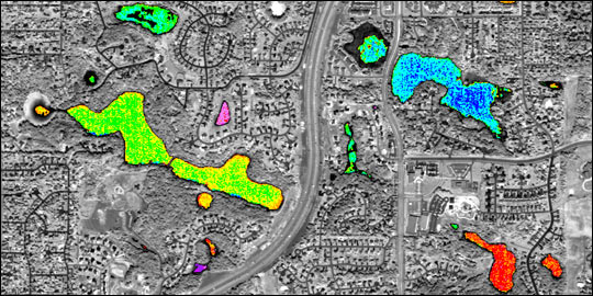
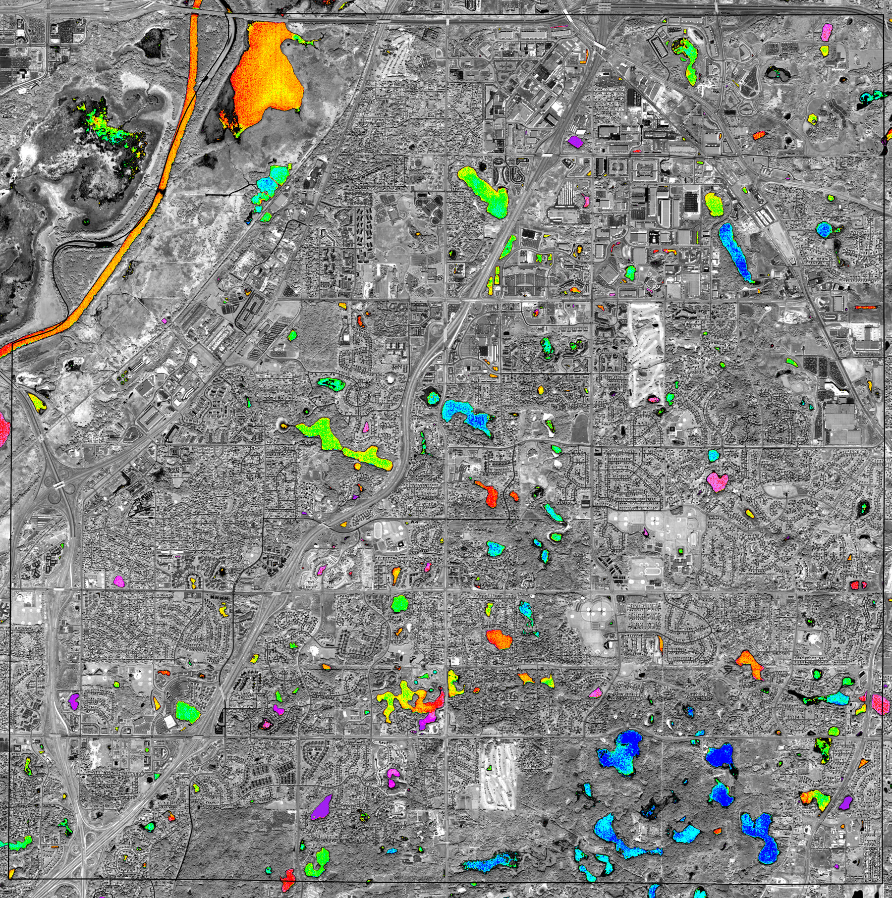
IKONOS data can be used to provide a “city-scale” map of lake water clarity like this one showing Eagan, Minnesota. Only eight of the more than 300 clarity measurements included in the full image (1.9 MB JPEG) were classified using the coarser resolution Landsat data over the same area. Clear lakes are blue, moderately clear lakes are green and yellow, and murky lakes are orange and red. (Image courtesy Upper Great Lakes Regional Earth Science Applications Center, based on data copyright Space Imaging) |
||
|
|
||
“But the real application of all this work will come in the future to track the progress of the lakes over time and understand how land cover change affects water quality,” says Brezonik. As part of the RESAC program, the researchers plan to compare maps of lake water quality with satellite maps that display land covers such as cropland, forests, wetlands, and urban areas. By linking land use and water clarity maps, the scientists hope to discern how urban sprawl and deforestation affect the water quality in the Upper Great Lakes region. The lake water quality maps will also be useful for diagnosing and managing lakes. Government agencies such as the Minnesota Pollution Control Agency and the Departments of Natural Resources in the three states can use updated versions of the maps to observe where water quality is deteriorating. The monitoring made possible by satellite remote sensing will help assure that lakes in the Upper Midwest are clean and fresh. References: Olmanson, L., P. Brezonik, S. Kloiber, M. Bauer, and E. Day, 2000: Lake water clarity assessment of Minnesota's 10,000 lakes: A comprehensive view from space. Proceedings, Virginia Water Research Symposium 2000 Advances in Land and Water Monitoring Technologies and Research for Management of Water Resources, Roanoke, VA, 215-232. Kloiber, S., T. Anderle, P. Brezonik, L. Olmanson, M. Bauer, and D. Brown, 2000: Trophic state assessment of lakes in the Twin Cities (Minnesota, USA) region by satellite imagery, Arch. Hydrobiol. Spec. Issues. Advanc. Limnol., 55, 137-151. |
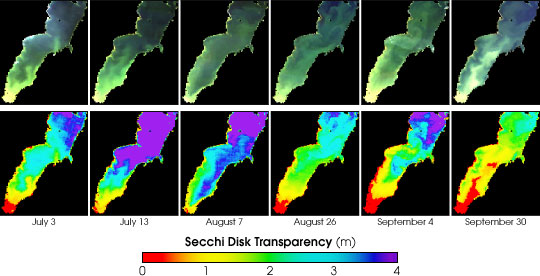
These images show true-color imagery and water quality data for Green Bay, Wisconsin during the summer of 2001. The Moderate-Resolution Imaging Spectroradiometer (MODIS) acquires data over a wider area and more frequently than Landsat, allowing researchers to track seasonal water clarity. (Images courtesy Jonathan Chipman, Center for Limnology and Environmental Remote Sensing Center, University of Wisconsin) |

