

by Holli Riebeek · design by Robert Simmon · June 28, 2005 The first pieces of evidence for climate change came from the land itself, from the misplaced boulders scattered across much of the Northern Hemisphere, though there were other signs as well. A homogeneous, fine yellow soil covered more than one million square miles of Europe, Asia, and North America. The soil was as thick as 3 meters (10 feet) in some places, and nearly nonexistent in others. Scientists eventually recognized that the soil, called loess (rhymes with “bus”), was made of rock that had been ground into powder under the weight and movement of the glaciers. As the ice melted, water swept the dust out from under the glaciers into streams along the edge of the ice. When water levels dropped, the dust blew across the land, leaving an uneven layer of fine, homogeneous soil. |
| ||
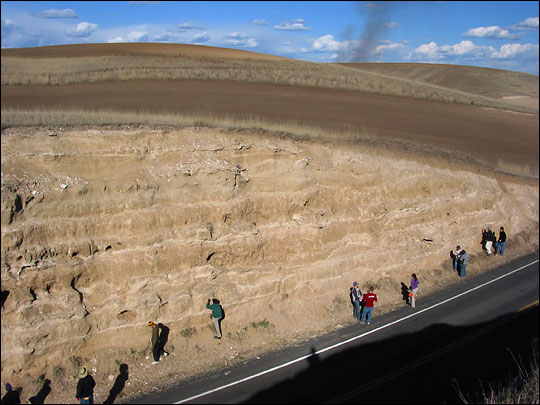 | |||
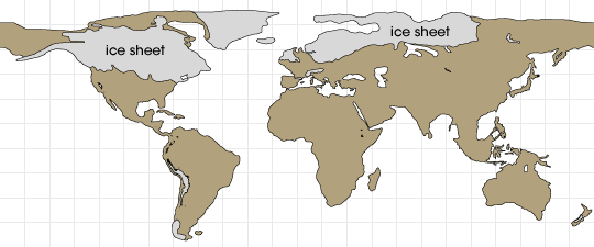
By mapping the loess and the trail of rock debris left by the glaciers, scientists determined that the ice sheets had once stretched down over the familiar bowls of the Great Lakes in North America and across the British Isles and Scandinavia. Thick glaciers, far larger than those that currently cap the mountain peaks, covered the Alps. In time, geologists discovered other layers of similar soil from earlier times—a sign that the climate had not changed just once, but at least three or four times. |
Loess deposits, composed of fine wind-blown dust produced by the grinding action of glaciers, indicate the former presence of ice sheets in locations around the Northern Hemisphere. This exposure of loess is near Palouse, Washington. (Photograph copyright Donald P. Schwert, North Dakota State University) | ||
 | |||
The story of glaciation and climate change may have been etched into rocks and brushed from the soil like a giant sand painting, but then Nature left the book out in the open. Exposed to erosion and weathering for thousands, even millions of years, some parts of the original story have been revised or become difficult to read. Buried in the Earth, however, is another version of the Earth’s climate story, and scientists have begun to leaf through its pages. Speleothems: Cave rocks |
Ice sheets covered much of North America, northern Europe, and Siberia during the last ice age. (Map adpated from Ray and Adams, 2001) | ||
A deep cavern dips into the New Mexico desert, shielding spiky icicle-like rocks that hang from the ceiling and the rounded columns that grow from the floor in a myriad of shapes. One of the world’s largest underground chambers, the Carlsbad Cavern is resplendent in the intricate finery of the rock formations that form there. Beyond their breath-taking beauty, the formations in Carlsbad and the more than 100 other caves in the area provide a record of rainfall in the southwestern United States. |
Spectacular rock formations in Carlsbad Cavern hold information on past rainfall and temperatures. (National Park Service Photo by Peter Jones) | ||
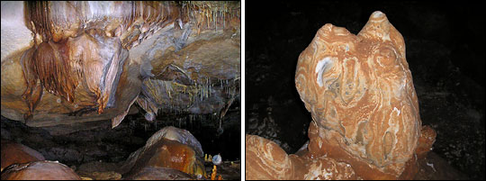
Tucked away inside the Earth, the rocks are protected from the weathering and large-scale erosion that taints other land-based climate records. As water runs through the ground, it picks up minerals, the most common of which is calcium carbonate. When the mineral-rich water drips into caves, it leaves behind solid mineral deposits—the same solid material that forms white spots on water faucets or glass dishes. The mineral deposits accumulate in the well-known icicle-shaped rock on the ceiling, a stalactite, and in a mound on the floor where the drip lands, a stalagmite. Less well known, water deposits can also dry in a flat slab called a flowstone. Geologists refer to the mineral formations in caves as “speleothems.” While the water flows, the speleothems grow in thin, shiny layers. The amount of growth is an indicator of how much ground water dripped into the cave. Little growth might indicate a drought, just as rapid growth could point to heavy precipitation. When the speleothems stop growing, the outside becomes dirty and eroded in places, giving it a dull appearance. A growing speleothem looks smooth and wet. |

Minerals dissolved in groundwater can crystallize on exposed surfaces of underground passages. The deposited minerals form stalactites, stalagmites, and other formations, collectively named speleothems. Soda straw stalactites are delicate tubes of calcium carbonate (limestone). (Photograph copyright Mouser Williams) | ||
 | |||
Scientists can date the layers in the speleothem by measuring how much uranium, a radioactive element, has decayed. Uranium from the surrounding bedrock seeps into the water and forms a carbonate that becomes part of each layer of the speleothem as it forms. Uranium decays into thorium, which sticks to the clay in the bedrock instead of seeping into ground water and from there into the speleothem. As a result, the newest layers of a growing speleothem typically contain no thorium. |
Flowing water builds stalactites, stalagmites, and flowstones one drip at a time (left). When a cave feature dries out (right), growth stops. (Photographs copyright Mouser Williams) | ||
|
Over time uranium predictably turns into thorium, so scientists can tell how old a layer is by measuring the ratio of uranium to thorium. Once the layers have been dated, scientists can create a rough record of how ground water levels changed over the lifetime of the formation. Because speleothem growth is influenced by geography, ground water chemistry, and other factors, the record from one cave cannot serve as a record of climate change. Scientists must look for similar patterns of growth in speleothems in caves over a broad area to infer that the climate changed. |

The cross section of a stalagmite reveals a sequence of layers, laid down over time. Researchers determine the age of the rings using Uranium-Thorium radioisotopic dating, and examine ring thickness and oxygen isotopes to determine past climate. (Photograph copyright Paul Williams, New Zealand National Institute of Water & Atmospheric Research) | ||
 |
 | ||
Scientists are trying to glean more climate information from speleothems. The rocks could provide a climate record through the oxygen isotope ratios. Oxygen in water comes in two important varieties for paleoclimate research: heavy and light. The ratio of these different types of oxygen in water vary based on air temperature, the total amount of ice in the world, and the amount of local precipitation—all important pieces of the climate puzzle. To an extent, the ratio is preserved in the cave rocks, and scientists can use this clue to learn about the climate at the time the rock formed. Recently, scientists have started to use the oxygen isotope ratio to track changes in the amount of rainfall (heavy rain results in more light oxygen) or changes in where the rain came from—the ocean or inland sources. “In southeast Brazil, for example, winter rain comes from the nearby Atlantic Ocean, but summer rain comes from the Amazon Basin,” says Stephen J. Burns, a geochemist at the University of Massachusetts. “The two have quite different oxygen isotope ratios.” By examining the ratios in the rocks, Burns and others can track seasonal changes and rainfall patterns. Since caves exist all over the Earth, speleothems have the potential to become a pivotal land-based climate record. Other land features help fill in the picture of climate in the past. Water marks trace the shorelines of ancient lakes where none exist now. Beaches record changes in sea level as ice sheets formed, and then melted. Dust deposits reveal where winds blew across ancient deserts. Fossils of animals and plants—even microscopic fossilized pollen grains—give clues about the climate where and when those organisms lived. |
Paleoclimatologists analyze the growth rate of stalactites and stalagmites to reveal patterns of past rainfall. This graph shows the thickness of near-annual growth rings for the past 450 years from a stalagmite in Carlsbad Cavern. Thick rings indicate a relatively wet climate, while thin rings indicate a dry climate. (Graph based on data from Polyak and Asmerom 2001, NOAA/NGDC Paleoclimatology Program) | ||
 | |||
While these artifacts in the Earth are valuable to scientists reconstructing large-scale climate patterns on land, most have been disturbed by subsequent weathering. For a global picture of past climate, scientists also need a consistent record that covers a broad section of the Earth. For that, they turn to the oceans.
|
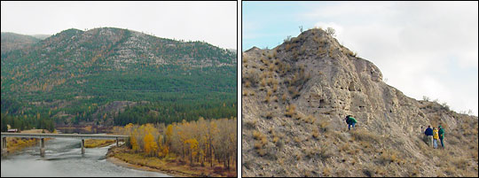
Features on the Earth’s modern surface hint at the surface in the past. After the last ice age, Glacial Lake Missoula left behind fossil shore lines (left)—flat, parallel benches—on many hillsides in western Montana. Layers of sediment, exposed by erosion (right), were also left behind by the lake. Researchers use these features to reconstruct past climates. (Photographs copyright Steven I. Dutch, University of Wisconsin-Green Bay) | ||