 | At first, Joaquim Goés’ prediction sounds a little like the kind of folklore you might find in a farmer’s almanac: low-snow winters across Europe and Asia will be followed by summers during which the amount of fish food in the Arabian Sea will skyrocket. Such a connection seems hard to believe; after all, thousands of miles and half a year separate the areas and the events. But in 2004, Goés, an oceanographer and remote-sensing expert from Bigelow Laboratory for Ocean Sciences in West Boothbay Harbor, Maine, and some of his colleagues put together a trail of evidence that they say leaves little doubt that the long-distance connection is real. Anyone interested in understanding how global warming will matter on a regional level should be interested in the connection says Goés. Interested…and probably a little concerned. Stumbling onto a DiscoveryAccording to Goés, the relationship between global warming, declining snow cover in Eurasia, and the food chain in the Arabian Sea were not even on his mind when he stumbled onto the discovery. In fact, he explained, he was simply trying to correct a mistake he had made on a separate project—or what he thought was a mistake at the time. |
||
“We were funded by NASA to come up with maps of nitrate concentrations in the world’s oceans based on satellite observations of chlorophyll and sea surface temperature,” he said. Nitrate is the major source of nitrogen for phytoplankton—the single-celled plants that are the foundation of the ocean food web—and knowing nitrate concentrations helps scientists model the ocean carbon cycle. |
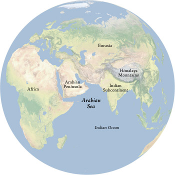
The Arabian Sea is connected to the Eurasian landmass by the winds of the Asian monsoon. Reduced snow cover over Eurasia to the north of India is strengthening the summer monsoon winds over the Arabian Sea. The strong winds bring nutrients to the sea surface, enhancing the growth of tiny marine plants called phytoplankton. (Natural Earth map courtesy Tom Patterson, U.S. National Park Service) | ||
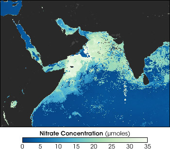
The problem, said Goés, was that after months of work on the project, it seemed like their mapping technique had a major bug: it didn’t seem to work for the Arabian Sea. According to the maps, nitrate amounts in the Arabian Sea during the summer months of July-August were way too high. Goés couldn’t find any estimates in the scientific literature that were as high as his team’s maps suggested. “So, we started this research as a way to backtrack from what we thought was a mistake in our technique for mapping nitrate.” |
Goés and his team discovered surprisingly high concentrations of nitrate in the surface waters of the Arabian Sea. While trying to determine if his results were correct, Goés discovered a complex chain of cause and effect between climate change, Eurasian snow cover, and the plant life in the Arabian Sea. This map shows nitrate concentrations from August of 2002, with blue indicating low levels and light green signifying high levels. (Map by Robert Simmon, based on data provided by Helga do Rosario Gomes, Bigelow Laboratory for Ocean Sciences) | ||
