| Implications of glacial shrinkage |
| ||
| In some cases,
a glacier that recedes around the edges may be growing thicker in areas near the
center. Since visible satellite sensors cannot penetrate the surface of the
glacier, scientists may be led to believe, at least in the short term, that the
glaciers are losing mass. Thus, a glacier must be measured for many years to detect
sustained changes in its edge or "ice front." |
|||
 "It is very hard to measure volume changes in
glaciers. People are required to put stakes in the glacier and come back a year
later to see how much of a change there is in the height of the glaciers," said
Hall. She said that this is a very labor-intensive activity and is done on very
few glaciers in the world. The only way to make sure the glacier is pulling
back due to a loss of mass is to study it over a period of many years. "It is very hard to measure volume changes in
glaciers. People are required to put stakes in the glacier and come back a year
later to see how much of a change there is in the height of the glaciers," said
Hall. She said that this is a very labor-intensive activity and is done on very
few glaciers in the world. The only way to make sure the glacier is pulling
back due to a loss of mass is to study it over a period of many years.
On average, scientists are finding that glaciers across the globe are steadily shrinking, said Hall. These findings confirm suspicions that the world is heating up. Researchers generally believe the warming trend may be the result of natural, cyclical changes of the Earth’s climate, and possibly in combination with effects of the large-scale burning of fossil fuels by humans since the industrial revolution. However, the cause of global warming is currently unknown. The last time the Earth warmed extensively, 120,000 years ago, the Greenland ice sheet drained into the ocean and the sea rose roughly 20 feet above where it is now (Williams and Hall, 1993). Such an increase today would flood coastal communities and low-lying countries such as Holland and Bangladesh, as well as much of the U.S. state of Florida. References
Additional References
|
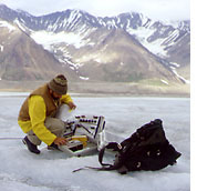
This scientist is setting up instruments to observe a glacier. Because glaciers are so large, remote, and widespread, it is impossible to measure them all from the ground, or even from aircraft. Satellites such as Landsat-7 are used in addition. (Photograph courtesy Dorothy Hall, NASA Goddard Space Flight Center) |
