| Using satellites to measure glaciers |
| ||
 The trick to measuring the extent of a glacier using a satellite image
lies in distinguishing the glacier’s edge from the surrounding land.
Unfortunately, this task isn’t as simple as drawing a line on the image
between what looks like a glacier and what looks like land. Both glaciers and
the surrounding ground often have the same dark gray coloring and can be easily
confused by sight. The trick to measuring the extent of a glacier using a satellite image
lies in distinguishing the glacier’s edge from the surrounding land.
Unfortunately, this task isn’t as simple as drawing a line on the image
between what looks like a glacier and what looks like land. Both glaciers and
the surrounding ground often have the same dark gray coloring and can be easily
confused by sight. |
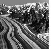
This aerial photograph
shows one of the problems inherent in studying glaciers with remote sensing. The dark
bands on the surface of the glacier, caused by ground-up rocks, make it difficult to distinguish
the glacier's edges from the surrounding terrain.
Barnard Glacier, AK · Austin Post Photo · July 29, 1957 (Photograph from the American Geographic Society Collection archived at the National Snow and Ice Data Center, University of Colorado at Boulder.) | ||
| To separate glacier from surrounding land more
accurately, scientists must look at specific types of light being reflected. As
can be seen through a prism, sunlight contains many different individual colors
(wavelengths). When sunlight strikes objects, certain colors of the spectrum
are absorbed and others are reflected. The reflected wavelengths give an object
its color.
Like most white objects, the glacier reflects nearly all the
colors of the visible spectrum, including the yellow-green sunlight. Yet,
a glacier absorbs near-infrared wavelengths of solar energy (light to the right of red
on the color spectrum). The research teams using the Landsat 5 and Landsat 7
satellites differentiate snow from other solid materials by looking at the
difference between the infrared and yellow-green wavelengths that are reflected.
Whenever the difference is large, the area in question is likely to be snow or
glacier ice (Hall et al. 1998). By tracking the edges of a glacier from year to
year, scientists are often able to see if it is receding or advancing. |
|||
 Hall explained, while satellite data are easier to collect than ground measurements, scientists still have to record images for many years before they can be certain a glacier is changing, and it is critical to abtain ground measurements to corroborate results deduced from analysis of satellite data. The most obvious reason for the scientists’ uncertainty has to do with the "resolution" of the satellite images. The Landsat 5 and Landsat 7 satellites have a resolution of 30 meters, which means that each pixel (or picture element) on the image represents a 30-by-30-meter patch of land. "Though the glacier will respond immediately to the changes in climate, it may take five to twenty years before we can see the changes in the glacier from satellites," said Hall.
|
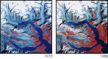
This pair of images from the Landsat series of satellites, taken more than a decade apart, shows the continuing retreat of the Muir glacier. The front face of the glacier is marked by the arrow in each image, and moved more than 7km between 1973 and 1986. (Image courtesy Dorothy Hall, NASA Goddard Space Flight Center) |
